Indian Holocaust My Father`s Life and Time - SIX HUNDRED TWENTY TWO
Palash Biswas
http://indianholocaustmyfatherslifeandtime.blogspot.com/
http://basantipurtimes.blogspot.com/
White Salty Dry Ocean and Intact Conch Bangles in DHOLAVIRA HARAPPAN METROPLIS Showcases Non Aryan Super Civilisation Destroyed by ARYAN Invaders!
I landed in Gandhidham, Kuchchh at 5PM on 13th April before scheduled time. Nagsi and Narang arrived shortly on the Palat farm shortly. I entered Gujarat in the Morning and first saw GODHRA, the place famous with Gujarat Genocide. Rest of Gujarat is an Amazing story of swift Urbanisation, Industrialisation and Infrastructure. Gandhidham is near Kandhla Port and Adani Power Plant is not so far.
Gandhidham is surrounded by SEZ on the land owned by Detribed KOLI and PARDHI aborigin people.
I visited SHAMAKHYALI also on the way to DHOLAVIRA.The journey between AHMEDABAD to Godhra is all about entering in the Industrilised world of Controversial Narendra Modi and his associate India Incs and MNCs.
I visited DHOLAVIRA, the Island amidst DRY SALTY White Ocean of Kuchchh RANN on 15th APRIL.
I addressed Public Meeting in Gandhidham at NIGHT on 14th APRIL as it was HOT. The atmosphere was tense as Stetue of Dr Ambedkar was broken at RAJKOT but we kept silence in the public meeting attended by no less than TEN THOUSAND SC, ST and OBC people from all parts of KUCHCHH as well as GUJARAT.
Dholavira Experience have enhanced my view of Linking the Missing Links of History. While I called back Home from the FIVE THOUSAND Years Old Metropolis Museum and informed her about the INTACT Five Thousand Years Old Conch bangles, she was EXCITED so much so that demanded to bring home the Bangles. The Conch Bangles are Mandatory for the Hindu Married woman in Eastern India Comprising Bihar, Bengal, Orissa, Assam and Tripura as well as in Bangladesh. The Idols resemble indigenous gods and goddesses. House appliances are same as found in Eastern parts of India.
The NON ARYAN Civilisation in Bengal and Eastern India is , NO DOUBT,directly LINKED with MOHANJODORA HARAPPA DHOLAVIRA LOTHAL Indus Saraswati Valley Civilisation.
-
Indus Valley Civilization - Wikipedia, the free encyclopedia
The Indus Valley Civilization (IVC) was a Bronze Age civilization (3300–1300 BCE; mature period 2600–1900 BCE) that was located in the northwestern region ...
en.wikipedia.org/wiki/Indus_Valley_Civilization - Cached - Similar -
The Harappan Civilization by Tarini J. Carr
The Harappan civilization once thrived some several thousand years ago in the Indus Valley. Located in what's now Pakistan and western India, it was the ...
www.archaeologyonline.net/.../harappa-mohenjodaro.html - Cached - Similar -
Images for harappan civilisation
- Report images


-
-
Harappa Civilisation
Information about ancient indian history of Harappa Civilisation.
www.indhistory.com/harappa-civilisation.html - Cached - Similar -
Harappan civilization in India - History for Kids!
3 Mar 2011 ... By around 2000 BC, though, the Harappan civilization had collapsed. We don't know what caused this collapse. Most people think the most ...
www.historyforkids.org/learn/india/history/harappa.htm - Cached - Similar -
The Harappan Civilization
A discussion of the mathematics and a astronomy of the Harappan Civilization.
visav.phys.uvic.ca/~babul/AstroCourses/P303/harappan.html - Cached - Similar - [DOC]
HARAPPAN CIVILISATION
File Format: Microsoft Word - Quick View
19 Aug 2007 ... It has a rich collection of a large number of artifacts from the sites ofHarappan Civilisation. The collection includes pottery, seals, ...
www.indiahabitat.org/.../Galleries%20of%20National%20Museum.doc - Similar -
Harappan civilisation had three growth epi-centres
In what may eventually help unveil the mystery behind the collapse of the Indus Valleycivilisation, Indian researchers have identified three distinct ...
www.deccanherald.com › National - Cached - Similar -
Indus Valley Civilisation- Indus Valley, Harappan Civilization ...
Ancient Indus River Valley Civilization thrived from 3300-1700 BC. Its name Harappan Civilization is based on the first unearthed city of Indus Valley.
www.culturalindia.net/indian-history/.../indus-valley.html - Cached - Similar -
Timeline results for harappan civilisation
More timeline results »2500 BC The findings, if confirmed, will dislodge the Harappan Civilisation dating back to2500 BC as India's oldest civilization.
www.hinduwisdom.info1900 BC Scolars state that mature Harappan civilisation lasted from c.2600 to 1900 BCE. With the inclusion of the predecessor and. successor cultures ...
books.google.com


The Road amidst White KUCHCHH RANN from Gnadhidham to Dholavira is no less than TWO Hundred KM and it was too HOT . We started a little late and reached the Ancient Metropolis around 1.00 AM. It took only four hours. Narang Garba was driving the AC Car. But the environment seemed to be fierce SUN STORM! Vinoy SURAI, NAGSI and SARNATH Gaikawad accompnied! They knew the local people and the staff at the Museum. They guided us in hot and hosted us.
We had meetings in the villages. We also met local people in Shamakhyali!
During journey to and fro Gandhidham, I came across cross section of people. I boarded the Gandhidham Express from Howrah after Midnight Two hours late than scheduled time at 1AM with Muslim People going to Bihar. A newly married couple from TRIVENI accompanied me upto Gandhidham. The Man Palash Mitra and his bride Tapati engaged me throughout. Tapti is from RISRA across Hugli from sodepur. In Return Journey from Gandhidha, I had to get my train from Ahmedabad. I traveld by Kamakhya Express. A group of boys from Tripura and Assam joined me who work in industries situated in saurashtra and Kutchh. The Tripuar boys belong to BILUNIA near Comilah bored and I visited the area with Marxists Ministers Anil Sarkar and Badal Chowdhuri way back in 2002. At the time, I also visited the archaeological site in the area which showcases the Indigenous aboriginal Buddhist Age in India. It was Exciting.
I got Ahemedabad Howrah Express after Midnight at 1AM. In the waiting room , a bright youngman from Jalaur, Rajasthan, GAHOLAT met me with the packed Dinner. Soon , another youngman from Jamnagar joined us. I was friendly with a Bihari family residing in Saurashtra and going to Hardwar, Uttarakhand , my home state. Little ANUSHKA was quite entertaining during the waiting. I Ahamedabd Express Muslim Families from Ranaghat, Bagula and Murshidabad joined me who boarded the train from Vadodara, Surat and Bharoch. There were some Maulavies who were perfoming Namaz. They intended to use their VOTE in Bengal Elections. They enquired about Bengal situation.I explained that it would NOT make any difference to the Excluded Communities including Muslims. It was also EXCITING.
But the most exciting experience was to FEEL the warmth of the foot print of our demonised destructed Ancestors FIVE THOUSAND Years old in Dholabira. The SUN Bite and Heat Wind did not matter at all.
Dholabira is situated as an ancient and small villagelocated at a corner of island of KHADIR situated in the Great RANN of Kuchchhin Bhachau Taluka of district Kachchh, gujarat.
The ancient site known as KOTADA (large fort) spans an area of about 100 hectares nearly half of which is appropiated by the fortified settlement of the HARAPPANS!The site is surrounded by two seasonal nallahs, Mansar in the north and Manhar in the south.
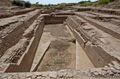
As a result of the extensive excavations, which are only ten percent to this date as UNESCO fund for the proposed World heritage is waited for the incomplete task,DHOLABRA nevertheless emerged as a major HARAPPAN city remarkable for its exquisite TOWN Planning, Monumental structures, Aesthetic architecture and amazing Water mangement and storage system which are quite absent in Mdern Metros like Delhi, Mumbai, Chennai and of course, KOLKATA!
I t has to be noted that DHOLABIRA has provided a long succession of Rise and Fall of FIRST INDIAN LITERAT URBAN SCIENTIFIC CIVILSATION which was the CENTRE ocf COMMERSE with rest of the world, Centarl Asia, MESOPOTAMIA and China!What the Aryans, zionist INVADERS, the ancestors of modernday foreigner Brahaminical Market dominating Class have DONE , it is quite clear with the evidence that the History and Heritage of URVBAN Ancient NON ARYAN may not be traced. But DHOLABIRA has a unique distinction of yielding an INSCRIPTIONof TEN arge signs of HARAPPAN SCRIPT, indeed the OLDEST sign Board in Human History which resembles the Chinese Japanese methodology of scripting! Moreover, a variety of funerary structures is another feature of exceeding important new light on the Socio Religious beliefsof Compsite liberal free ETHNIC groups in the Indian aborigine demography of the Harappan Metropolis, contrary to the ARYAN Monoplistic Civilisation based on ETHNIC Cleansing and GENOCIDE Cultre sustained even today with hardcore Zionist Mnusmriti Rule of the Global Order!
The identification of a Stadium with adequate seating arrangement and introduction of MIDDLE Town added a new feature to Harappan studies.The archaeological excavations at the site near LARKANA na MOHANJODORO across the Border, have revealed seven significant CULTURAL stages documenting the rise and fall of the first Indigenous URBANIZATION in the South Asian Geopolitics.
Stage one: The first settlers resided there with ADVANCED Ceramic Techniques, Copper workings, Lithic industry,bead making,stone dressingand certain principles of Planningand architecture. They constructed a formidable fortification around the Settlement. The houses were made of moulded mudbricks of standard sizes.
Stage Two: It is marked with widening of the fortification,increase of ceramic forms, decorations and in the quantity of minor antiquites.
Third stage: it is understod to be very CREATIVE period in Dholabira. The small settlement grew into a large town having Two Fortified major divisions in addition to annexes and water reservoirs, all within the peripheral wall.The exciting fortified settlement was in fact made into CITADEL and another fortified sub division was added to it in the West. These Two sub divisions had been designed and designated as CASTLE and BAILY respectively.The Brahaminical officials of the EXCAVASION deny any Aryan INVASION and try their best to Establish that the Civilisation and earlier Literate settlement had been DAMAGED by Natural calamity like Earthquake of SEVER Magnitude and consequently, large scale repairs were executed and significant changes were made in the Planing. However , it proves the SUPERIOR Technical Expertige of our ancestors. And it is said that the City was EXTENDED Eastwards.during the substage, the monumental gateways alongwith their front terraces were introduced
Stage Four belongs to CLASSICAL HARAPPAN Civilistion and Culture so liberal and Developed.The famous INSCRIPTION of Ten large sized signs of the Harappan script found in the North Gate should also pertain to the stage. All the Calssical harappan elemenst as Pottery,SEALs, Lithic Tools, Beads, wieghts and other items of Gold, Copper, stone , SHELL and Clay have been found which have been BRANDED as ARYAN in So Cllaed sanatan Hindu Aryan heritage denying the EXISTANCE of Indigenous Supremacy.Among most impressiveitems are elements of Functional pillars and free standing COLUMNs made of locally available Lime stones.
Stage Five is caharcterised by the generakl decline particularly in maintenace of the city as is more vividly reflected in the citadel. However , the other items such as Pottery, seals etc continued to develop.
Archaelogical experts claim that the Stage Six presents an entirely different form of the Harappan Culture that has been found widely distributed in other Parts of GUJARAT. the culture might have been undergone DRASTIC Transformation by improving and incorprating in it diverse pottery traditions coming from the sites of SIND, south Rajasthan and Gujarat while many HARAPPAN traditions ,albiet in changed formsand styles, were still sustained in Pottery, Seal satmp and wieghts.
At DHOLAVIRA, traces of late Harappan Culture is present !
Stage SEVEN depicts the ARRIVAL of New Comers who are said to be closely related to their predecessors.
The new people constructed their houses in an entirely new form which was CIRCULAR and were ESTABLISTED on the destructed site.
How came the DESTRUCTION? Who were Responsible?
The Brahamins would NEVER Disclose.
Thus, EXCAVATION are Interupted in different sites countrywid to wipe out the NON ARYAN Heritage and sustaining Bloddy INVADER Aryan Supremacy!
Search Results
-
3700 BC 3700 BC - The Sorath (present Saurashtra) region civilisation, dating back to 3700 BCE at some places, was distinct from the classical Harappan as it developed in the Indus Valley, say researchers in the field. "It maintained its separate identity in many ways,'' said ...
Show more
From Stone Pages Archaeo News: A civilisation parallel to Harappa? - Related web pages
www.stonepages.com/news/archives/001051.html -
3000 BC 3000 BC - Excavations in Kalibangan, near Ganganagar in northern Rajasthan, have unearthed terracotta pottery and jewellery that date back to around 3000 BC, conclusively dating the earliest spread of settlements in the state to that time. Some of these urban centres ...
Show more
From Rajasthan, Delhi & Agra - Related web pages
books.google.com/books?id=Zz0_zXPb68kC&pg=PA27 ... -
2600 BC 2600 BC - Origin of Civilisation Most of the western scholars held the view that Harappan civilisation was not an indigenous one.
Show more
From optional indian history ancient india
books.google.com/books?id=RSsYmi8uU-gC&pg=PA16 ... -
2500 BC 2500 BC - The findings, if confirmed, will dislodge the Harappan Civilisation dating back to2500 BC as India's oldest civilization.
From Hindu Wisdom - aryan_invasion_theory - Related web pages
www.hinduwisdom.info/aryan_invasion_theory14.htm -
2000 BC 2000 BC - Interestingly, this unit was used by Harappan civilisation settlement sites on the Indus valley in 2000 BC. The Kautilya's Arthasastra also mentions about the measurement unit of angulams and says that 12 angulams equal one vitasti while ten dhanus equal to ...
Show more
From India Journal - South Asian News for Southern California - Related web pages
www.indiajournal.com/pages/event.php?id=7796 -
1900 BC 1900 BC - Scolars state that mature Harappan civilisation lasted from c.2600 to 1900 BCE. With the inclusion of the predecessor and. successor cultures — Early Harappan and Late Harappan, respectively — the entire Indus Valley Civilisation may be taken to have ...
Show more
From Indian Cultural Heritage Perspective For Tourism - Related web pages
books.google.com/books?id=u21tp_JG9I0C&pg=PA5 ... -
1800 BC 1800 BC - Around 1800 BC, the Harappan Civilisation started declining. Most of the big cities were abandoned. In the remaining settlements, people used inferior building materials. The uniformity of weights and measures was also lost. Various causes have been cited for ...
Show more
From Longman History & Civics ICSE 9 - Related web pages
books.google.com/books?id=EXPouL4BYTMC&pg=PA25 ... -
1700 BC 1700 BC - By combining the results of these craft studies with similar information on subsistence, we are now beginning to better understand Harappan civilisation. The occupation of the site continued in the post-urban period up to 1700 BC. In the last phase there are ...
Show more
From Antiquity: Project Gallery - Related web pages
www.antiquity.ac.uk/projgall/bhan304/ -
1500 BC 1500 BC - When the ancient Indian Harappan sites (of the Indus Valley civilisation) were discovered, it was clear that these reflected a much older civilisation than could be attributed to the supposed coming of the Vedic Aryans in 1500 BCE. At this point, the Aryan ...
Show more
From MoreArticles1 - Related web pages
www.salagram.net/VWH-MoreArticles1.html -
700 BC 700 BC - The citadel may be a part of Harappan civilisation, possibly serving as a link between contemporary South Asian and Roman civilisations. The Harappan civilisationflourished in the Indus and Ganges valleys between 2700 BC and 700 BC. In Wari and the ...
Show more
From loving-bengal.net - Related web pages
www.sos-arsenic.net/lovingbengal/culture.html
Science And Technology In Harappan Culture
The Harappan people achieved great accuracy in measuring length, mass and time. The people of Indus valley civilization were among the first to develop a system of uniform weights and measures. Their smallest division which is marked on an ivory scale found in Lothal was approximately 1.704mm the smallest division ever recorded on a scale of the Bronze Age.
Harappan followed the decimal division of measurement for all practical purposes including the measurement of mass as revealed by their hexahedron weights. These brick weights were in a perfect ration of 4:2:1 with weights of 0.05,0.1,0.2,0.5,1,2,5,10,20,50,100,200 and 500 units with each unit weighing approx 28 grams and smaller objects were weighed in similar ratios with the units of 0.871.Unique Harappan inventions include an instrumentwhich was used to measure whole sections of the horizon and the tidal dock.They also evolved new techniques in metallurgy and produced copper,bronze,lead and tin.the engineering skills of Harappans was remarkable especially in building docks after a careful study of tides,waves and currents. A touchstone bearing gold streaks was found in Banawali which was probably used for testing the purity of gold.
http://www.zahie.com/categories/details/history/science-and-technology-in-harappan-culture.html
-
Religion, Science & Astronomy of Harappa Civilization
Religion, Science & Astronomy of Harappa Civilization. ... However Historian John Keays in his book on Religion of Harappans countered this view. ...
reference.indianetzone.com/.../religion,_science_astronomy.htm - Cached - Similar -
Religion in Indus Valley Civilization
2 Nov 2010 ... Religion in Indus Valley Civilization - Informative ...
www.indianetzone.com › ... › Indus Valley Civilization - Cached - Similar -
Hinduism (religion) :: Religion in the Indus valley civilization ...
Hinduism (religion), Religion in the Indus valley civilization, Britannica Online Encyclopedia, The Harappa culture, located in what is now Pakistan, ...
www.britannica.com/.../Religion-in-the-Indus-valley-civilization - Cached - Similar -
Images for religion of harappan civilization
- Report images


-
Indus Valley Civilization Religion, Religion Of Indus Valley ...
Religion Of Indus Valley Civilization, Notes On Indus Valley Civilization Religion.
www.historytution.com/indus...civilization/religion.html - Cached - Similar -
The Harappan Civilization by Tarini J. Carr
- 10:18amThe Harappan civilization once thrived some several thousand years ago in the ... and imposed their own culture and religion on them, as the theory goes, ...
www.archaeologyonline.net/.../harappa-mohenjodaro.html - Cached - Similar -
Harappa Civilisation
Harappa Civilisation - Religion. The culture and religion of the IVC overlap and perhaps repetitive symbols such as the pipal leaf and swastika have ...
www.indhistory.com/harappa-civilisation.html - Cached - Similar -
Indus Valley Civilisation- Indus Valley, Harappan Civilization ...
Religion The large number of figurines found in the Indus Valley Civilization suggests that the Harappan people worshipped a Mother Goddess, who symbolized ...
www.culturalindia.net/indian-history/.../indus-valley.html - Cached - Similar -
History - The Indus Valley Civilisation
Mohenjodaro and Harappa are now in Pakistan and the principal sites in ... Society andReligion The Harappan society was probably divided according Goddess ...
sympweb.tripod.com/IndusValleyhistory.htm - Cached - Similar -
History of Hinduism - ReligionFacts
17 Mar 2004 ... Knowledge of this great civilization's religion must therefore be based ...Period to the decline of the Indus civilization » Post-Harappan ...
www.religionfacts.com/hinduism/history.htm - Cached - Similar


| ||||||
| ||||||
| |


Dholavira
Dholavira, an ancient city, and locally known as Kotada Timba Prachin Mahanagar Dholavira, is one of the largest and most prominent archaeological sites in India, belonging to the Indus Valley Civilization. It is located on the Khadir bet island in the Kutch Desert Wildlife Sanctuary, Great Rann of Kutch, Kachchh district of Gujarat, India. The site is surrounded by water in the monsoon season.[1] The site was occupied from c.2650 BCE, declining slowly after about 2100 BCE. It was briefly abandoned and reoccupied until c.1450 BCE.[2] The site was discovered in 1967-8 by J.P. Joshi and is the fifth largest Harappan site in the Indian subcontinent, and has been under excavation almost continuously since 1990 by the Archaeological Survey of India. Eight large urban centers have been discovered: Harappa, Mohenjo Daro, Ganeriwala, Rakhigarhi, Kalibangan, Rupar, Dholavira, and Lothal.
Contents[hide] |
Chronology of Dholavira
R.S. Bisht, the director of the Dholavira excavations, has defined following seven stages of occupation, at the site[3]:
| Stages | Dates | |
|---|---|---|
| Stage I | 2650-2550 BCE | Early Harappan - Mature Harappan Transition A |
| Stage II | 2550-2500 BCE | Early Harappan - Mature Harappan Transition B |
| Stage III | 2500-2200 BCE | Mature Harappan A |
| Stage IV | 2200-2000 BCE | Mature Harappan B |
| Stage V | 2000-1900 BCE | Mature Harappan C |
| 1900-1850 BCE | Period of desertion | |
| Stage VI | 1850-1750 BCE | Posturban Harappan A |
| 1750-1650 BCE | Period of desertion | |
| Stage VII | 1650-1450 BCE | Posturban Harappan B |
Excavations
The ancient site at Dholavira, is flanked by two storm water channels; the Mansar in the north, and the Manhar in the south. Excavation was initiated in 1989 by the Archaeological Survey of India under the direction of R. S. Bisht. The excavation brought to light the sophisticated urban planning and architecture, and unearthed large numbers of antiquities such as seals, beads, animal bones, gold, silver, terracotta ornaments and vessels linked to Mesopotamia. Archaeologists believe that Dholavira was an important centre of trade between settlements in south Gujarat, Sindh and Punjab and Western Asia.[4]
Architecture and material culture
Estimated to be older than the port-city of Lothal, the city of Dholavira has a rectangular shape and organization, and is spread over 100 hectares. The area measures 771.10 metres in length, and 616.85 metres in width. Like Harappa and Mohenjo-daro, the city is composed to a pre-existing geometrical plan, of three divisions - the citadel, the middle town and the lower town. The acropolis and the middle town had been further furnished with their own defence-work, gateways, built-up areas, street system, wells and large open spaces. The acropolis is the most carefully guarded as well as impressive and imposing complex in the city of which it appropriates the major portion of the southwestern zone. The towering "castle" stands majestically in fair insulation and defended by double ramparts. Next to this stands a place called 'bailey' where important officials lived. The city within the general fortification accounts for 48 hectares. There are extensive structure-bearing areas though outside yet intimately integral to the fortified settlement. Beyond the walls, yet another settlement has been found. The most striking feature of the city is that all of its buildings, at least in their present state of preservation, are built out of stone, whereas most other Harappan sites, including Harappa itself and Mohenjo-daro, are almost exclusively built out of brick.[5]
Reservoirs

One of the unique features of Dholavira is the sophisticated water conservation system of channels and reservoirs, the earliest found anywhere in the world and completely built out of stone, of which three are exposed. They were used for storing the fresh water brought by rains or to store the water diverted from a nearby rivulet. This probably came in wake of the desert climate and conditions of Kutch, where several years may pass without rainfall.
The inhabitants of Dholavira created sixteen or more reservoirs of varying size during Stage III. Some of these took advantage of the slope of the ground within the large settlement, a drop of 13 m from northeast to northwest. Other reservoirs were excavated, some into living rock. Recent work has revealed two large reservoirs, one to the east of the castle and one to its south, near the Annexe.[6]
Reservoirs are cut through stones vertically. They are about 7 meters deep and 79 meters long. Reservoirs skirted the city while citadel and bath are centrally located on raised ground.[7] A large well with a stone-cut trough to connect the drain meant for conducting water to a storage tank also found.[7] Bathing tank had steps descending inwards.
Other structures and objects
A huge circular structure, believed to be grave or memorial is found. However no skeleton or human remains found under structure. The circular structure is built with ten radial walls of mud bricks in a shape of spoked wheel.[7] A soft sandstone sculpture of a male with phalluserectus but head and feet below ankle truncated was found in the passage way of the eastern gate.[7] Also many funerary structures were found, however except one they were devoid of skeletons. Also many pottery pieces, terracotta seals, bangles, rings, beads and intaglio engraving found.
Language and Script
It is not known which language the Harappan people spoke, and their script cannot be read. It had about 400 basic signs, with many variations. The signs may have stood both for words and for syllables. The direction of the writing was generally from right to left. Most of the inscriptions are found on seals (mostly made out of stone) and sealings (pieces of clay on which the seal was pressed down to leave its impression). Some inscriptions are also found on copper tablets, bronze implements, and small objects made of terracotta, stone andfaience. The seals may have been used in trade and also for official administrative work. A lot of inscribed material was found at Mohenjo-daro.
Sign board

One of the most significant discoveries at Dholavira was made in one of the side rooms of the northern gateway of the city. The Harappans had arranged and set pieces of the mineral gypsum to form ten large letters on a big wooden board. At some point, the board fell flat on its face. The wood decayed, but the arrangement of the letters survived. The letters of the signboard are comparable to large bricks that were used in nearby wall. Each sign is about 37 cm high and the board on which letters were inscribed was about 3 meter long.[8]
How to reach Dholavira
Dholavira is located in the Kutch Desert Wildlife Sanctuary in the Great Rann of Kutch.
- By Air
- The nearest airport is in Gandhidham about 250 km away, where a daily flight between Mumbai and Gandhidham is available. Another airport close to Dholavira is Bhuj Airport about 300 km away, where daily two flights between Bhuj and Mumbai are available.
- By Rail
- Samakhyali (160 km) on the Palanpur-Gandhidham BG line.
- By Road
References
- ^ http://whc.unesco.org/en/tentativelists/1090/
- ^ http://www.britannica.com/EBchecked/topic/160814/Dholavira
- ^ Possehl, Gregory. (2004). The Indus Civilization: A contemporary perspective, New Delhi: Vistaar Publications, ISBN 81-7829-291-2, p.67.
- ^ http://www.archaeology.org/0011/newsbriefs/aqua.html
- ^ http://accidentalblogger.typepad.com/accidental_blogger/2008/08/water-managemen.html
- ^ Possehl, Gregory. (2004). The Indus Civilization: A contemporary perspective, New Delhi: Vistaar Publications, ISBN 81-7829-291-2, p.69.
- ^ a b c d United News of India (1997-06-25). "Dholavira excavations throw light on Harappan civilisation". Indian Express. Archived from the original on 2008-09-30. Retrieved 2008-10-15.
- ^ Possehl, Gregory. (2004). The Indus Civilization: A contemporary perspective, New Delhi: Vistaar Publications, ISBN 81-7829-291-2, p.70.
External links
- Excavations at Dholavira in Archaeological Survey of India website.
- Computer graphics reconstruction of Dholavira
- The Old World - Dholavira
- Dholavira (Gujarat, India)
- Dholavira excavations throw light on Harappan civilisation, United News of India 1997
- Nisid Hajari, "India's Salt Lake Cities", in Time Magazine 1 September 1997
- World Heritage Site, All Tentative Sites, Here is an overview of all Tentative list, last updated June, 2006.
- World Heritage, Tentative Lists, State : India.
- Dholavira: a Harappan City, Gujarat, Disstt, Kachchh - UNESCO World
- Jurassic Park: Forest officials stumble upon priceless discovery near Dholavira; Express news service; Jan 08, 2007; Indian Express Newspaper. Also see [1], [2]
- Trip Record: Photos of Friends on a motorbike trip through Kutch visiting the Great Rann of Kutch passing through Kala Dungar (Black hill), snow white Rann, then they visit the Dholavira Harappan excavation site. Then biking through Banni grasslands they see Indian Wild Ass there and Chari-Dhand Wetland Conservation Reserve. They then Bike to Lakhpat fort village and also Mandvi beach.. Also see[3].
- ASI's effort to put Dholavira on World Heritage map hits roadblock; by hitarthpandya; Feb 13, 2009; Indian Express Newspaper
- ASI to take up excavation in Kutch's Khirasara; by Prashant Rupera, TNN; 2 November 2009; Times of india
-
Dholavira Maps - Tourist, Tourism map of Dholavira
Explore tourism map of Dholavira. Road map of Dholavira city and surrounding destinations.... Dholavira. Kutch. Kandla. Bhuj. Gandhidham. Morvi. Wankaner ...
www.holidayiq.com › India › Gujarat - Cached -
Dholavira Ruins, Kutch, Dholavira Ruins in Kutch
indianholiday.com offers online information on Dholavira Ruins, Kutch, Dholavira Ruins ...Kutch Dholavira Ruins carry some of the very elegant and precious ...
www.indianholiday.com/.../dholavira-ruins-kutch.html - United States - Cached - Similar -
Images for dholavira kutch
- Report images


-
Kutch India Tour - Dholavira
Khadir Island tour: Dholavira (Kutch Tours) - tour #2115, Khadir Island private tour, Khadir Island private guide.
www.toursbylocals.com/DholaviraHarrapanTourGiude - Similar -
Dholavira: Kutch Desert Wildlife Sanctuary, Dholavira Tourist ...
Kutch Desert Wildlife Sanctuary - Dholavira places.
www.mustseeindia.com/Dholavira-Kutch-Desert-Wildlife.../18623 - Cached -
Dholavira, Indus Valley Civilization, Lothal - KutchForever.com
Above all the Harappan sites, the site of Dholavira nearby known as Kotada, in the Khadir island of Kutch stands separately. ...
www.kutchforever.com/Dholavira.aspx -Great Rann of Kutch
From Wikipedia, the free encyclopediaThe Great Rann of Kutch[1] also called Greater Rann of Kutch[2] or just Rann of Kutch (Gujarati: કચ્છનું મોટું રણ), is a seasonal salt marsh located in the Thar Desertin the Kutch District of Gujarat, India and the Sindh province of Pakistan.
The name "Rann" comes from the Hindi word ran (रण) meaning "salt marsh". The Hindi word is derived from Sanskrit/Vedic word iriṇa (इरिण) attested in the Rigvedaand Mahābhārata.
Contents
[hide][edit]Location and description
The Great Rann of Kutch, along with the Little Rann of Kutch and the Banni grasslands on its southern edge, is situated in the district of Kutch and comprises some 30,000 square kilometres (10,000 sq mi) between the Gulf of Kutch and the mouth of the Indus River in southern Pakistan. The marsh can be accessed from the village of Kharaghoda in Surendranagar District.
In India's summer monsoon, the flat desert of salty clay and mudflats, averaging 15 meters above sea level, fills with standing waters, interspersed with sandy islets of thorny scrub, breeding grounds for some of the largest flocks of Greater and Lesser Flamingoes, and is a wildlife sanctuary [7]. At its greatest extent, the Gulf of Kutch on the west and the Gulf of Cambay on the east are both united during the monsoon.
During the flooding wildlife including the Indian Wild Ass shelters on islands of higher ground called bets.
The area was a vast shallows of the Arabian Sea until continuing geological uplift closed off the connection with the sea, creating a vast lake that was still navigable during the time of Alexander the Great. The Ghaggar River, which presently empties into the desert of northern Rajasthan, formerly emptied into the Rann of Kutch, but the lower reaches of the river dried up as its upstream tributaries were captured by the Indus and Ganges thousands of years ago. Traces of the delta and its distributary channels on the northern boundary of the Rann of Kutch were documented by the Geological Survey of India in 2000.
The Luni River, which originates in Rajasthan, drains into the desert in the northeast corner of the Rann and other rivers fedding into the marsh include the Rupen from the east and the West Banas River from the northeast.
This is one of the hottest areas of India.
[edit]Flora
The plant life of the marsh consists of grasses such as Apluda and Cenchrus species along with dry thorny shrubs.
[edit]Wildlife
The Rann of Kutch is the only place[citation needed] in Pakistan and India where flamingoes come to breed. There are 13 species of lark in the Rann of Kutch. The Little Rann of Kutch is famous for the Indian Wild Ass sanctuary, where the worlds last population of Indian Wild Ass (Equus hemionus khur or khar) still exists. Other mammals of the area include the Indian Wolf (Canis indica), Desert Fox (Vulpes vulpes pusilla), Golden Jackal (Canis aureus), Chinkara (Gazella bennettii), Nilgai (Boselaphus tragocamelus), and the threatened Blackbuck(Antilope cervicapra).
The marshes are also a resting site for migratory birds, and are home to over 200 species of bird including the threatened Lesser Florican(Eupodotis indica) and Houbara Bustard (Chlamydotis undulata).
[edit]Threats and preservation
Although most of the marsh is in protected areas the habitats are vulnerable to cattle grazing, firewood collection and salt extraction operations, all of which may involve driving road vehicles and this disturbing wildlife. There are several wildlife sanctuaries and protected reserves on the Indian side in the Rann of Kutch region. From the city of Bhuj various ecologically rich and wildlife conservation areas of the Kutch/Kachchh district can be visited such as Indian Wild Ass Sanctuary, Kutch Desert Wildlife Sanctuary, Narayan Sarovar Sanctuary,Kutch Bustard Sanctuary, Banni Grasslands Reserve and Chari-Dhand Wetland Conservation Reserve, etc.
On the Pakistani side in the Sindh province the Pakistani Government has created the Rann of Kutch Wildlife Sanctuary.
[edit]Indo-Pakistan international border
In India the northern boundary of the Greater Rann of Kutch forms the International Border between India and Pakistan, it is heavily patrolled by Border Security Force (BSF) and Indian Army conducts exercises here to acclimatize its troops to this harsh terrain.[1][2]
This inhospitable salty lowland, rich in natural gas is part of India and Pakistan's ongoing border dispute concerning Kori Creek. In April 1965, a dispute there contributed to the Indo-Pakistani War of 1965, when fighting broke out between India and Pakistan. Later the same year,Prime Minister of the United Kingdom Harold Wilson successfully persuaded both countries to end hostilities and set up a tribunal to resolve the dispute. A verdict was reached in 1968 which saw Pakistan getting 10% of its claim of 9,100 square kilometres (3,500 sq mi). The majority of the area thus remained with India. Tensions spurted again in 1999 during the Atlantique Incident.
[edit]Chir Batti
In dark nights an unexplained strange dancing light phenomena known locally as Chir Batti (ghost lights) is known to occur here in the Rann[3] and in the adjoining Banni grasslands and its seasonal marshy wetlands.[4]
[edit]In popular culture
J. P. Dutta's Bollywood film Refugee is shot on location in the Great Rann of Kutch and other locations in the Kutch district of Gujarat, India. This film is attributed to have been inspired by the famous story by Keki N. Daruwalla based around the Great Rann of Kutch titled "Love Across the Salt Desert"[5] which is also included as one of the short stories in the School Standard XII syllabus English text book of NCERTin India.[6] The film crew having traveled from Mumbai was based at the city of Bhuj and majority of the film shooting took place in various locations around in the Kutch District of the Indian state of Gujarat including the Great Rann of Kutch (also on BSF controlled "snow white" Rann within), Villages and Border Security Force (BSF) Posts in Banni grasslands and the Rann, Tera fort village, Lakhpat fort village, Khera fort village, a village in southern Kutch, some ancient temples of Kutch and with parts and a song filmed on set in Mumbai's Kamalistan Studio.
[edit]See also
- Little Rann of Kutch
- Kutch
- Kori Creek
- Atlantique Incident
- Banni grasslands
- Chhir Batti (Ghost lights) from Banni grasslands, its seasonal wetlands and the adjoining Rann of Kutch
- Chari-Dhand Wetland Conservation Reserve adjacent to Banni Grasslands
- Salt marsh
- Salt flat
[edit]References
- ^ a b Fighting for the Great Rann - It's a desolate, barren tract of land, but the armed forces guard it with a fierceness that inspires nothing short of awe. By Gaurav Raghuvanshi; Feb 25, 2005; Business Line; Financial Daily from THE HINDU group of publications
- ^ a b Far from the focus - Villages along the India-Pakistan border face official neglect and inadequate assistance. By PRAVEEN SWAMI in Bhuj; Volume 18 - Issue 04, Feb. 17 - Mar. 02, 2001; Frontline Magazine; India's National Magazine from the publishers of THE HINDU
- ^ Stark beauty (Rann of Kutch); Bharati Motwani; September 23, 2008; India Today Magazine, Cached: Page 2 of 3 page article with these search terms highlighted: cheer batti ghost lights rann kutch [1], Cached: Complete View - 3 page article seen as a single page [2]
- ^ Ghost lights that dance on Banni grasslands when it's very dark; by D V Maheshwari; August 28, 2007; The Indian Express Newspaper
- ^ Love Across the Salt Desert; by Keki N. Daruwalla. Pdf of full story posted at Boston University at [3]. Bollywood connection - J. P. Dutta's "Refugee" is said to be inspired by this story; learnhub, University of Dundee
- ^ (iii) Supplementary Reader; Selected Pieces of General English for Class XII; English General - Class XII; Curriculum and Syllabus for Classes XI & XII; NCERT. Also posted at [4] / [5], [6]
Encyclopædia Britannica
 This article incorporates text from a publication now in the public domain: Chisholm, Hugh, ed (1911).Encyclopædia Britannica (Eleventh ed.). Cambridge University Press.
- The Great Run of Kutch; Dec 10, 2006; The Indian Express Newspaper
- Rann of Kutch seasonal salt marsh (IM0901); Ecoregion Profile, Flooded Grasslands and Savannas; World Wildlife Fund Report; This text was originally published in the book Terrestrial ecoregions of the Indo-Pacific: a conservation assessment from Island Press. This assessment offers an in-depth analysis of the biodiversity and conservation status of the Indo-Pacific's ecoregions. Also see: Rann of Kutch seasonal salt marsh (IM0901); Flooded Grasslands and Savannas; WildWorld; All text by World Wildlife Fund © 2001; National Geographic Society
[edit]External links

Wikimedia Commons has media related to: Rann of Kutch - Rann of Kutch Festival Astrology
- World Wildlife Fund: Terrestrial Ecoregions: Rann of Kutch
- Satellite views comparing summer and winter conditions in the Rann of Kutch
- Little Rann of Kutch National Park
- Kachchh Portal a web portal about Kachchh and the people who hail from there - the global community of Kachchhis / Kutchis.
- Worldwildlife.org website
- Desert (Rann of Kutch) wetlands; 06 February 2003; WWF Global website
- KACHCHH PENINSULA AND THE GREAT RANN; The Geological Survey of India, Ministry of Mines, Government of India
- Archived News Articles from India Environmental Portal on: Rann of Kutch
- Archived News Articles from India Environmental Portal for a Search made for: Banni grasslands
- Trip Record: Photos of Friends on a motorbike trip through Kutch visiting the Great Rann of Kutch passing through Kala Dungar (Black hill), snow white Rann, then they visit the Dholavira Harappan excavation site. Then biking through Banni grasslands they see Indian Wild Ass there and Chari-Dhand Wetland Conservation Reserve. They then Bike to Lakhpat fort village and also Mandvi beach.. Also see[8].
[show]Geography of South Asia [show]Protected areas of Pakistan


SATURDAY, JANUARY 8, 2011
DHOLAVIRA-A HARAPPAN METRO
A journey to Dholavira:a Harappan metropolis
 * * |
DHOLAVIRA |
 * * |
DHOLAVIRA |
| * |
DHOLAVIRA WRITING |
| * |
STREET |
The road to dholavira goes through a dazzling white landscape of salty mudflats. It is close to noon in early April and the mercury is already past 100F. The desert monotones are interrupted only by the striking attire worn by the women of the nomadic and semi-nomadic pastoral tribes that still inhabit this land: Ahir, Rabari, Jat, Meghwal, and others. When I ask the driver of my hired car to stop for a photo, they receive me with curious stares, hoots, and giggles.The Rann of Kutch, an area about the size of Kuwait, almost entirely within Gujarat and along the border with Pakistan. Once an extension of the Arabian Sea, the Rann ("salt marsh") has been closed off by centuries of silting. During the monsoons, parts of the Rann fill up with seasonal brackish water, enough for many locals to even harvest shrimp in it. Some abandon their boats on the drying mudflats, presenting a surreal scene for the dry season visitor. Heat mirages abound. Settlement is limited to a few "island" plateaus, one of which, Khadir, hosts the remains of the ancient city of Dholavira, discovered in 1967 and excavated only since 1989.Entering Khadir, we pass a village and find the only tourist bungalow in town. It hasn't seen a visitor in three days; I check in and head over to the ruins. I've planned this for months; even the hottest hour of the day cannot temper my excitement for the ruins of this 5,000 year-old metropolis of the Indus Valley Civilization. While hundreds of sites have been identified in Gujarat alone, this is among the five biggest known to us in the entire subcontinent, alongside Harappa, Mohanjo-daro, and Ganeriwala in Pakistan, and Rakhigarhi in India.At the site office, a caretaker and his friend are playing cards on a charpoy. They offer me a chair and a glass of water, cooled in an earthen surahi. On a wall are the mysterious inscriptions from the famous signboard of Dholavira, painted above contemporary motifs to suggest a continuity of sorts. I learn from the caretaker that the Archaeological Survey of India (ASI) still excavates each winter, alongside researchers from overseas. Hundreds from the local village are then employed on site. He says he has learned directly from the experts and offers to be my guide. I readily agree but hope that as part of the deal, he will overlook the "Photography Prohibited" injunction I had noticed earlier—a perfectly exasperating habit of the ASI—else I would have to attempt a bribe. I am relieved when the caretaker does not press the issue.***To the casual visitor, the most striking feature of Dholavira is its water management system. One gets the sense that every drop of water had to be saved. About 25 of the city's 250 acres are occupied by 16 rock cut reservoirs of various sizes. Linked by channels and dams, the reservoirs are quite spread out and must have added to the aesthetic appeal of this planned city. I wondered how much of the city's energy went into this effort? What drew its citizens to this location in the first place?Archaeologists have identified seven cultural stages in the city's evolution, starting around 3000 BCE. The "golden age" was apparently the fourth stage, when most of its monumental structures—gateways, fortifications, reservoirs—were built, accompanied by a prolific output in pottery, seals with inscriptions, weights, beads, and items of gold, silver, copper, ivory, shell, faience, steatite, clay, and stone. Later stages saw rising levels of impoverishment and urban decay (and a brief revival), until it was finally abandoned around 1500 BCE. We can't be sure why. But Dholavira did outlast other major centers of the Indus Valley Civilization.The city was enclosed by an outer wall. Three major sections of the city have been identified: the "citadel", "middle town", and "lower town", in descending order of prosperity and civic amenities. To the south on higher ground stands the citadel, where the "royalty" had lived. Further north is the middle town and a lower town to its east, both residential quarters for commoners, with streets and homes laid out on a grid-like plan. The caretaker points out portable wastewater pots (sullage jars) outside many houses, similar to the large earthenmatkas of today. Pottery shards lie scattered on the ground. I pick up a broken stone bangle. Someone probably wore this 4000 years ago!The imposing citadel, fortified with layers of walls, gates, and towers, has a "castle" atop with concealed passageways, stairs, and chambers, many supported by chiseled pillars of finely polished limestone. What dramas unfolded within these walls? What fears and hopes were expressed here? Or myths, anxieties, humor, repressions, prejudices? Unless the Harappan "script" is deciphered, much of what we say is speculation. What we can be sure of is Dholavira's water harvesting acumen, plainly evident in the citadel's intricate network of storm water drains, with slopes, steps, cascades, manholes, paved flooring and capstones. A tall man could walk through the large arterial drains that fed a reservoir on the citadel. The caretaker leads me to a deep well, once fitted with ropes and buckets. Water drawn from it cascaded down rock-cut channels to feed showers in a royal bathroom. Who were the people who occupied this privileged spot? What social organization supported them?Between the citadel and middle town is an open field, with stepped stands on all four sides. It might have hosted a market, royal or religious ceremonies, sports, executions, performances, or festivals. Though there is no evidence of competitive sports, some Indian historians prefer to believe so and have accordingly dubbed the field a "stadium". Overlooking this field was the citadel's north gate with the famous three-meter wide signboard of ten mysterious symbols, which must have been legible from across the field. For all we know, it might say: Long Live the King or Conserve Water!With the region's water resources clearly not ideal for agriculture, what economic activity drove the city's fortunes? Scholars have suggested that Dholavira, with its coastal location may have been a regional hub of maritime trade and commerce (back then the Rann was a navigable channel to the Arabian sea). To the modern visitor, Dholavira could well be a symbol of an epic struggle against the elements, where a whole city strived to wrestle an order out of its hostile environment. All that for what? The stones aren't talking just yet. |
Posted by hssthistory2010@gmail.com at 6:40 AM
-
Harappa - Wikipedia, the free encyclopedia
The ancient city of Harappa was greatly destroyed under the British Raj, when bricks from the ruins were used as track ballast in the making of the ...
en.wikipedia.org/wiki/Harappa - Cached - Similar -
Images for harappan cities
- Report images


-
Harappan civilization in India - History for Kids!
3 Mar 2011 ... There were two main cities that we know of, Harappa and Mohenjo-Daro, about 400 kilometers (250 miles) away. Both are in modern Pakistan. ...
www.historyforkids.org/learn/india/history/harappa.htm - Cached - Similar -
The Harappan Civilization by Tarini J. Carr
- 10:18amThe Harappan civilization once thrived some several thousand years ago in the Indus Valley. Located in what's now Pakistan and western India, it was the ...
www.archaeologyonline.net/.../harappa-mohenjodaro.html - Cached - Similar -
Harappa
"Harappa was a `city' site; but the Sarasvati and Sindhu rivers had nurtured a large number of `village' sites. The state of archaeological knowledge has ...
ancienthistory.about.com/library/weekly/aa041498.htm - Cached - Similar -
Harappa Civilization
Mohenjo and Harappa were the planned cities. They were the two biggest cities, 600 km apart. They had similar planning, layout and technique in construction ...
www.indiaandindians.com/india.../harappan_civilization.php - Cached - Similar -
The Harappan Civilization
A discussion of the mathematics and a astronomy of the Harappan Civilization.
visav.phys.uvic.ca/~babul/AstroCourses/P303/harappan.html - Cached - Similar -
Mohenjo-daro the Ancient Indus Valley City in Photographs
Ancient Indus Valley city of Mohenjo-daro in 103 Slides by Dr. Jonathan Mark Kenoyer. ...Harappa.com does not support or condone the sale of antiquities. ...
www.mohenjodaro.net/ - Cached - Similar -
Harappa Civilisation
Information about ancient indian history of Harappa Civilisation.
www.indhistory.com/harappa-civilisation.html - Cached - Similar -
Town Planning of Harappa Civilization
The twin cities of Mohenjo-daro and Harappa were center of all activities. Both cities were a mile square, with defensive outer walls. ...
reference.indianetzone.com/1/town_planning.htm - Cached - Similar -
Timeline results for harappan cities
More timeline results »2600 BC 2600 BC Mature Harappan phase of the Indus Valley Civilization begins. The citiesof Harappa, Lothal, Kalibangan and Mohenjo-daro become large ...
botanyias.blogspot.com1900 BC Named after its city of Harappa, the civilization flourished from 2600 to 1900 BCE, developing a technologically advanced urban culture that was ...
www.thefreedictionary.com


Kutch District
| | This article needs additional citations for verification. Please help improve this article by adding reliable references. Unsourced material may be challenged and removed.(June 2010) |
| | This article may require cleanup to meet Wikipedia's quality standards. Please improve this article if you can. The talk page may contain suggestions. (March 2009) |
| Kachchh district કચ્છ જિલ્લો | |
|---|---|
 Location of Kachchh district in Gujarat | |
| State | Gujarat, |
| Headquarters | Bhuj |
| Area | 45,612 km2 (17,611 sq mi) |
| Population | 1,526,321 (2001) |
| Population density | 33 /km2 (85.5/sq mi) |
| Sex ratio | 951 |
| Lok Sabha Constituencies | Kachchh |
| Assembly Seats | 6 |
| Major highways | 1 |
Kutch district (also spelled as Kachchh) (Gujarati: કચ્છ જિલ્લો, Sindhi: ڪڇ ضلو) isdistrict of Gujarat state in western India. Covering an area of 45,612 km², it is the largest district of India.
Kachchh literally means something which intermittently becomes wet and dry; a large part of this district is known as Rann of Kachchh which is shallow wetlandwhich submerges in water during the rainy season and becomes dry during other seasons. The same word is also used in the languages of Sanskrit origin for a tortoise and garments to be worn while having a bath. The Rann is famous for its marshy salt flats which become snow white after the shallow water dries up each season before the monsoon rains.
The district is also famous for ecologically important Banni grasslands with their seasonal marshy wetlands which form the outer belt of the Rann of Kutch.
Kachchh District is surrounded by the Gulf of Kachchh and the Arabian Sea in south and west, while northern and eastern parts are surrounded by the Great and Small Rann (seasonal wetlands) of Kachchh. When there were not many dams built on its rivers, the Rann of Kachchh remained wetlands for a large part of the year. Even today, the region remains wet for a significant part of year. The district had a population of 1,583,225 of which 30% were urban as of 2001.[1] Motor vehicles registered in Kutch district have their registration Number starting with GJ-12.
Contents[hide] |
[edit]Geography
The Kachchh district, with 45,652 km², is one of the largest districts(Ladakh is the largest) in India. The administrative headquarters is in Bhujwhich is geographically in the center of district. Other main towns are Gandhidham, Rapar, Nakhatrana, Anjar, Mandvi, Madhapar andMundra. The district has 966 villages.
Kachchh is virtually an island, as it is surrounded by the Arabian Sea in the west; the Gulf of Kachchh in south and southeast and Rann of Kachchh in north and northeast. The border with Pakistan lies along the northern edge of the Rann of Kachchh, of the disputed Kori Creek. The Kachchh peninsula is an example of active fold and thrust tectonism. In Central Kachchh there are four major east-west hill ranges characterized by fault propagation folds with steeply dipping northern limbs and gently dipping southern limbs. From the gradual increasing dimension of the linear chain of hillocks towards the west along the Kachchh mainland fault and the epicentre of the earthquake of 2001 lying at the eastern extreme of Kachchh mainland fault, it is suggested that the eastern part of the Kachchh mainland fault is progressively emerging upward. It can be suggested from the absence of distinct surface rupture both during the 1956 Anjar earthquake and 2001 Bhuj earthquake, that movements have taken place along a blind thrust. Villages situated on the blind thrust in the eastern part of the Kachchh mainland hill range (viz. Jawaharnagar, Khirsara, Devisar, Amarsar and Bandhdi) were completely erased during the 2001 earthquake.[2]
[edit]Wildlife Sanctuaries and Reserves of Kutch
From the city of Bhuj various ecologically rich and wildlife conservation areas of the Kutch / Kachchh district can be visited such as Indian Wild Ass Sanctuary, Kutch Desert Wildlife Sanctuary, Narayan Sarovar Sanctuary, Kutch Bustard Sanctuary, Banni Grasslands Reserve andChari-Dhand Wetland Conservation Reserve etc..
[edit]Culture
[edit]Language
The languages spoken predominantly in Kachchh is Gujarati, Kachchhi and to lesser extent Sindhi, and Hindi. Script of Kachchhi language has become extinct and it is mainly written in the Gujarati script. Samples of Kachchhi script are available in Kachchh Museum. Increased use of Gujarati language is mainly because of being it a medium of instruction in schools. Often Kachchhi language is mistaken as dialect of Gujarati, however this is not true. Kachchhi language bears more grammatical similarity with Sindhi and words with Gujarati.
[edit]People

Kutch district is inhabited by various groups and communities. Many of these have reached this region after centuries of migration from neighbouring regions of Marwar (Western Rajasthan), Sindh,Afghanistan and further. Even today, one can find various nomadic, semi nomadic and artisan groups living in Kutch.Some communities came from Sind,(mostly Kutchi speaking-Lohanas,Bhatiyas,Khatris..)and some from Saurashtra.(Gujarati speaking-Sorathiya,Ahir,Girnara..)Many migrated from north Gujarat ,especially in Vagad region(Gujarati speaking- Prajapati)
The major groups such as the Lohana, Bhatia, Kapdi, Khumbar, Jadeja, Gadhvi, Darbar, Kathis,Rajputs, Mali Samaj, Leva Patel, Kadva Patel, Brahmins, Nagar Brahmins, Nandwana Brahmins,Khatris, Rabaris, Rajgor, Shah, Bhanushali, Jains (Visa and Dasa Oswal), Kutch Gurjar Kshatriyas,Mistris, Kharwa, Meghwals, Wankars, Vankaras, Ahirs, and many others have adopted a settled lifestyle and have struck a life rhythm close to that of modern-day towns. The Banni region is home to a number of nomadic Sindhi-speaking Muslim groups such as the Dhanetah Jaths, Halaypotra,Sanghar [Kutch Muslam Sanghaar Jamat-now in Karachi] Pakistan Hingora, Hingorja, Rahima,Bhadala, Mutwa, Raysipotra, Sammas, Theba and Node, maintain more traditional lifestyles.
[edit]Economy and Industries
| | This article may contain wording that merely promotes the subject without imparting verifiable information. Please remove or replace such wording, unless you can cite independent sources that support the characterization. |
Kutch is a growing economic and industrial hub in one of India's fastest growing states - Gujarat. Its location on the far western edge of India has resulted in the commissioning of two major ports Kandla and Mundra. These ports are near most to the Gulf and Europe by the sea route. The hinterland of north-western India hosts more than 50% of India's population. Quality of roads is good in Kutch. The large part of the growth of Kachchh came after tax relief provided by the government as part of 2001 earthquake relief.
Due to the existence of 2 major ports, transportation as a business has thrived. Since historical times the people of Kutch have formed the backbone of trade between Gujarat mainland and Sindh. After the formation of Pakistan this trade stopped for good, but due to the inception of the Kandla port, trade boomed again.
Kutch is Mineral rich region with very large reserve of Lignite,[3] Bauxite, Gypsum among other minerals. Kachchh got tax break for Industries for 15 years after the major earthquake on January 26, 2001. Lignite is mined only by Gujarat Mineral Development Corporation (GMDC) at its 2 mines in Panandhro and Mata-No-Madh. The Panandaro mines has now been reserved for GEB and GMDC power plants and GMDC has stopped supply to other industries from there.[4] This has adversely affected local trucking business.
Kutch also houses Sanghi Industries Ltd's Cement Plant. It is the India's single largest Cement Plant[citation needed]. The company is now planning to increase the capacity at its Abdasa location from 3–9 million tons per annum.[5] By 2015, the company plans to produce 20 million tons.[5] Kandla port is also in Kutch. It is considered Gateway to India's North. It is managed by the Kandla Port trust.
Other major Industries in Kutch are TATA POWER's first 4000 MW Ultra Mega Power Project(UMPP)of India. Adani Power expects to tie up funds for it's 3300 MW plant by March 2012 and is on track to complete the installation of 10,000 MW projects by 2013. The other major companies are the Welspun Group of Companies, Ajanta Clocks,Orpat , JayPee Cements, Jindal Steel and One of the largest windmill farms concentration. Kutch region is also a major producer of salt.
Kucth district has a scanty forest cover. Hence there is negligible risk of illegal cutting of forests. This coupled with the adequate facilities available at Kandla port has helped establish the timber market. In 1987, "Kandla Timber Association" was formed in order to resolve the specific, problems of Timber Importers and Timber allied industries coming up during the period. The Timber industry is growing at a faster pace with 300 saw mills working in Gandhidham-Kandla Complex.
The Little Rann of Kutch is known for its traditional salt production and various references mention this to be a 600 years old activity. During the British period, this activity increased manifold. It was used to fund a substantial part of the military expenses of the British government. Communities involved in salt production are mainly Chunvaliya Koli, Ahir and Miyana (Muslim), residing in 107 villages in the periphery of Lesser Rann of Kutch. These communities are traditionally known to have the skills of salt production and are known as 'Agariyas'. Water quality in 107 villages of Lesser Rann of Kutch is saline, thus agriculture is not an option .Hence salt production is the only livelihood option for Agariyas. As per the Salt Commission's report there are 45000 Agariyas working in the salt pans of Kutch. Out of the estimated total annual production of India of about 180 lakh tonnes, Gujarat contributes 75% - mainly from Kutch and other parts of Saurashtra.
Other Traditional industries in the areas include manufacture of Shawls, handicrafts, and silver items.
[edit]Handicrafts
Kachchh has a strong tradition of crafts.
The most famous craft of the region is its diverse embroideries. The finest aari embroidery was carried out for the royalty and wealthy families. Traditionally women in rural areas do the embroidery for their dowries.[6] Unfortunately many of these fine skills have now been lost, though some are being rejuvenated through handicrafts initiatives. In 1950, local social leader Dr. Manubhai Pandhi worked with local artists and the central government to help the dying handicraft. Today over 16 types of embroidery are being produced commercially by a few societies and a couple of private corporations. Some of the finest new embroidery in the world is being produced by over 6,000 women artisans of the region.
Some of the embroideries still being produced in the region are
- Kapdi (bava)
- Jadeja
- Gadhvi (Charan)
- Ahir
- Pakko
- Neran
- Kambira
- Khudi Teba
- Chicken
- Katri
- Chopat
- Gotan
- Mukko
- Soof
- Kharek
- Jat - Gracia
- Jat - Fakirani
- Noday
- Jat Daneta
Embroidery styles like Zardosi, Bhanusali, Jain, etc. are today extinct and one can see old pieces in museums or with collectors only.
Important resource centers for embroidery in the region are Shrujan, Kutch Mahila Vikas Sangathan (KMVS), Kalaraksha and Women Artisans' Marketing Agency (WAMA).
Another important art of Kutch is bandhani, which primarily originated in the region. Women wear saris of bandhani art on festive occasions like marriages or holidays like Navaratri and Diwali.
Kutch has a history of very fine quality Ajarakh printing. This is a very complex hand printing technique using wooden blocks and natural dyes. Similar techniques are seen in Bardmer in Rajasthan and Sind in Pakistan. The Ajarakh from each region has some subtle differences. Technically the Ajarakh printed today in Kutch is by far the finest of the lot. The printing is done by a lengthy process which can take up to a couple of months for the most complicates pieces. Ajarakh is being practised today in Dhamadka and Ajarakhpur villages in Kutch.
Mud work is another artwork of Kutch. Artistic wall pieces made with mud and mirror work are used to decorate homes.
Handmade, copper-plated cattle bells that are artistically calibrated to a note are made in the region. The bells have a very sweet and distinct sound that, although very soft, can travel very large distances in the open desert. These bells were traditionally put around cattle necks so that they could be easily located if they get lost. The bells are made by approximately 25 families in the villages of Zura, Nirona and Bhuj.
Kutch has many leather artisans who make products like shoes, sandals, mirrors, small pouches, etc. from leather. Traditionally hand tanned leather was used but has been almost replaced completely by leather imported from outside. The very high skilled artisans decorate the articles by doing embroidery or cutting various shaped windows in the leather. These artisans can be found in the villages like Sumarasar, Nirona, Zura, Bhirandiyara, Hodko, Khavda, etc. in and around the Banni region.
Lacquer work is carried out by the Vadha community. This group used hand-operated lathes to shape wood and decorate it with lacquer which is colored. The simple but highly skilled technique creates beautiful products which are a delight to see.
Kutch is home to a school of handloom weaving. The weavers weave wool, cotton and acrylic yarn to make products like shawls, yardage, jackets, etc. Bandhani (tie-dye) is carried out on the shawls in some cases. The biggest center for this is Bhujodi village near Bhuj.
[edit]Religion
As per the 2001 census, the district's population was 1,526,331, of which most around are Hindu. The remainder of the population adhere to mostly Jainism and Islam. There are also some Sikhs and a Gurudwara is also situated in kachchh at Lakhpat. This Gurudwara was originally a house where the first Guru Guru Nanak stayed during his journey to Mecca. The Swaminarayan Sampraday has a huge following in this region. Their main temple in this district is Shri Swaminarayan Mandir, Bhuj. Anjar city is the really famous also as Swaminarayan Mandir and Swaminarayanians. A related Sarswat Brahmin are called Kutchhi Sarswat Brahmin. Maheshwari (Maheshpanthi) Shampraday.
[edit]Food and drink
The majority of the population is vegetarian. Jains, Buldhmins and some other caste perform strict vegetarianism. Jains also refrain from eating kandmool food grown below the ground such as potatoes, garlic, onion, suran, etc. Hindus perform various degree of vegetarianism but certainly do not eat beef.
In the villages, staple foods include bajra and milk; bajara na rotla with curd and butter milk is very common food for all the Gujarati people. Bajra was introduced by a brave king of this region named Lakho Fulani. During his period of exile, he came to know about this grain in some tribal regions. They also extensively drink buttermilk during lunch. Milk is considered to be sacred food and offering it to somebody is considered a gesture of friendship and welcoming. Settlement of dispute invariably follows offering milk to each other as a concluding remark. In the Kutchi engagement ceremony, the bride's family offers milk to the groom's relatives as a symbol of accepting their relationship.
Tea is the most popular drink in this region and is enjoyed irrespective of sex, caste, religion or social status. Tea stalls where groups of people chat over tea are invariable sights of every village or town entrance from early morning to late evening. Most people drink it with milk and sugar. Offering black tea to guests is considered to be a bad gesture. Tea without milk is offered when people are visiting host to mourn death of relatives. Tea was introduced in this region by the British as part of medicinal purpose to counteract the plague epidemic in the early 19th century. Alcoholic liquor is another popular drink, though it has been illegal to drink or possess since Kutch was incorporated within Gujarat. Most of the liquor drunk in this region is distilled from molasses by local people in villages. As a rule, women do not drink alcohol.
[edit]History
Remote and sparsely populated while the district of Kutch may be, it has had an interesting history. The Indus valley civilization, known to be one of the first ever civilised societies consisted of the ancestors of Kutchis as well as others. However now most of the river lies in Pakistan after India was split up.
[edit]Prehistoric period
A few major towns of the Indus Valley Civilization are located in Kachchh. Dholavira, locally known as Kotada Timba, is one of the largest and most prominent archaeological site in India belonging to the Indus Valley Civilization. It is located on the Khadir island in the northern part of the Kachchh district - the island is surrounded by water in the monsoon season. The Dholarvira site is believed to have been inhabited between 2900 BCE and 1900 BCE, declining slowly after about 2100 BCE, briefly abandoned and then reoccupied, finally by villagers among its ruins, until about 1450. ZAARA no Yuddh is considerd to be one of the most fierce battle after Mahabharat was battled in Lakhpat taluka.
[edit]Medieval and British period
Kutch was formerly an independent kingdom, founded in the late 13th century by a Samma Rajput branch called Jadeja Rajputs. The Jadeja dynasty ruled not only Kutch but also much of neighboring Kathiawar for several centuries until the independence of India in 1947. In 1815 Kutch became a British protectorate and ultimately a princely state, whose local ruler acknowledged British sovereignty in return for local autonomy. Bhuj was the Capital of Princely State of Kutch. One surviving relic of the princely era is the beautiful Aina Mahal ("mirror palace"), built in the 1760s at Bhuj for the Maharao of Kutch by Ram Singh Malam who had learnt glass, enamel and tile work from the Dutch. Along with that during that time period Kutch had its own currency, while the rest of British India was using rupees. The Maharao also had built at his expense the Cutch State Railway.
[edit]Modern period

Upon the independence of India in 1947, Kachchh acceded unto the dominion of India and was constituted an independent commissionaire. It was created a state within the union of India in 1950. On June 1, 1948, Chhotalal Khovshaldan Desai became first Chief Commissioner of Kutch State. He was succeeded by Sambhajirao Appasaheb Ghatge in 1952. He was in office till October 31, 1956. On November 1, 1956, Kachchh State was merged with Bombay state, which in 1960 was divided into the new linguistic states of Gujarat and Maharashtra, with Kachchh becoming part of Gujarat state.
On the Partition of India in 1947, the province of Sindh, including the port of Karachi, became part of Pakistan. The Indian Government constructed a modern port at Kandla in Kutch to serve as a port for western India in lieu of Karachi. There was a dispute over the Kutch region with Pakistan and fighting broke out just months before the outbreak of the Second Kashmir War. Pakistan claimed 3,500 sq mi (9,100 km2) of the land and an international tribunal was set up. It awarded 350 sq mi (910 km2) of the claimed land to Pakistan, the rest remaining with India. Tensions flared again during the Atlantique Incident as it came just weeks after the 1999 Kargil Conflict.
The epicentre of the 2001 Gujarat Earthquake was in this district. It was the most severe of the more than 90 earthquakes that hit Kutch in 185 years. Much of Bhuj was destroyed or damaged, as were many villages. Many of the attractions of Bhuj, including the Aina Mahal, have still not been restored as of 2009.
[edit]Major Bollywood film shootings
J. P. Dutta's Bollywood film Refugee is shot on location in the Great Rann of Kutch and other locations in the Kutch district of Gujarat, India. This film is attributed to have been inspired by the famous story by Keki N. Daruwalla based around the Great Rann of Kutch titled "LOVE ACROSS THE SALT DESERT"[7] which is also included as one of the short stories in the School Standard XII syllabus English text book ofNCERT in India.[8] The film crew having traveled from Mumbai was based at the city of Bhuj and majority of the film shooting took place in various locations around in the Kutch District of the Indian state of Gujarat including the Great Rann of Kutch (also on BSF controlled "snow white" Rann within), Villages and Border Security Force (BSF) Posts in Banni grasslands and the Rann, Tera fort village, Lakhpat fort village, Khera fort village, a village in southern Kutch, some ancient temples of Kutch and with parts and a song filmed on set in Mumbai's Kamalistan Studio.
Just after the film shooting of Refugee finished, the film crew of another Bollywood film "Lagaan" descended on Bhuj in Kutch and shot the entire film in the region, employing local people and villagers from miles around. A set of a full period Village was constructed for the film with typical Kutch style mud houses or huts with thatched straw roofs called boongas.[9]
Kutchi people in other parts of the world : Trinidad and Tobago , Kenya, Tanzania, U.K and Guyana, Province of Sindh, Pakistan. Kuthci people proud to be Kutchi in Karachi and rest part of Sindh,
[edit]See also
| | Wikimedia Commons has media related to: Kutch District |
- 2001 Gujarat earthquake
- Bhuj
- Gandhidham
- Harilal Upadhyay
- Khavda
- Nakhatrana
- Mandvi
- Rann of Kutch
- Banni grasslands
- Princely State of Cutch
[edit]References
- ^ [1]
- ^ Karanth, R. V.; Gadhavi, M. S. (2007-11-10). "Structural intricacies: Emergent thrusts and blind thrusts of central kachchh, western india".Current Science 93 (9): 1271–1280
- ^ The brown gold of Kutch - By tapping the huge mineral deposits of the Kutch region, Gujarat Mineral Development Corporation Ltd. plans to turn the backward area into a prosperous one.; SPECIAL FEATURE: GUJARAT; By V.K. CHAKRAVARTI; Volume 20 - Issue 06, March 15–28, 2003; Frontline Magazine; India's National Magazine from the publishers of THE HINDU
- ^ Steel Guru
- ^ a b "SIL to set up cement plant in Kutch" (cms). News article (Ahmedabad: Times of India). 2007-06-30. Retrieved 2008-08-12.
- ^ Elson, Vickie (6 1979). Museum of Cultural History, University of California.
- ^ LOVE ACROSS THE SALT DESERT; by Keki N. Daruwalla. Pdf of full story posted at Boston University at [2]. Bollywood connection - J. P. Dutta's "Refugee" is said to be inspired by this story; learnhub, University of Dundee
- ^ (iii) Supplementary Reader; Selected Pieces of General English for Class XII; English General - Class XII; Curriculum and Syllabus for Classes XI & XII; NCERT. Also posted at [3] / [4], [5]
- ^ Google Books Preview: "The spirit of Lagaan - The extraordinary story of the creators of a classic"; by Satyajit Bhatkal; Published by Popular Prakshan Pvt. Ltd.; ISBN 81-7991-003-2 (3749)
- The Great Run of Kutch; Dec 10, 2006; The Indian Express Newspaper
- Hotel Prince - Hotel in Kutch
[edit]External links
| |||||||||||||||||||||||||||

Gandhidham
| | This article may require cleanup to meet Wikipedia's quality standards. Please improve this article if you can. The talk page may contain suggestions. (September 2010) |
| Gandhidham | |
| — city — | |
| | |
| Coordinates | 23.08°N 70.13°ECoordinates: 23.08°N 70.13°E |
| Country | India |
| State | Gujarat |
| District(s) | Kachchh |
| President | Meenaben A Bhanusali |
| Municipality | Gandhidham Municipality |
| Population | 166,388 (2001) |
| Time zone | IST (UTC+5:30) |
| Area | • 27 metres (89 ft) |

Gandhidham (Gujarati: ગાંધીધામ, Sindhi: گانڌيِ ڌام) is a city and a municipality in the Kachchh District of Gujarat state of India. The town was created in the early 1950s for the resettlement of the refugees from Sindh of Pakistan in the aftermath of the partition of India. In recent history Gandhidham is a fast developing city in Gujarat state.
Contents[hide] |
[edit]History
Soon after the separation of Pakistan from India in 1947, a large group of refugees from Sindhof Pakistan came to India. Maharaja of Kutch His Highness Maharao Shri Vijayrajji Khengarji Jadeja on advice of Gandhiji, gave 15,000 acres (61 km2) of land to Bhai Pratab, who founded Sindhu Resettlement Corporation to rehabilitate Sindhi Hindus uprooted from their motherland.[1] Sindhi Resettlement Corporation was formed ( fondly called SRC)withAcharaya Kriplani as chairman and Bhai Pratap Dialdas as managing director. Main objective of the corporation was to assist in the rehousing of displaced persons by the construction of new town on a site few miles inland from location selected by Government of India for new port of Kandla on the Gulf of Kachchh. The first plan was prepared by a team of planners headed by Dr. O. H. Koenigsberger, director of the division of housing in Government of India. Subsequently plan was revised by Adams Howard and Greeley company in 1952. The foundation stone of town was laid with blessings of Mahatama Gandhi and hence town was named Gandhidham.
It is said that it was barren land with snakes and scorpions so numerous, Bhai Pratap had to offer compensation 25 paise to kill a scorpion and 50 paise to kill a snake in this area.[1] The first plan envisaged 400,000 as ultimate population of town, expecting half of it would reach in mid seventies. Revised plan envisaged three stages of town development with mid stage lasting longer with population around 150000. The single largest challenge before town planners was to overcome problem of poverty of its residents. Since major part of its population was made up of either refugees or laborers of port, free trade zone and railway, even a cost of single toilet exceeded their earnings of year. Hence in beginning, houses were made with one room and a kitchen, without water driven sewage. Residents have to draw water from nearby community tap, which were provided one for every ten to twelve family. Every row of houses had a narrow alley in back so sweepers can access it to remove sewage manually. Nevertheless town and modern and beautiful look because of its wide streets and rectangular neighborhoods. Areas allocated for recreational facilities were half of the US standard of such facilities in 1950. The town has big open grounds to facilitate Garba and Social gatherings. Another challenge in neighborhood design was to channel traffic on main streets so traffic should not flow through neighborhood streets, which otherwise would have been the case with wide streets. From very begin of the town planning, it was expected that Town will benefit from port and free trade zone related activities and only in later stage will have other manufacturing activities around it. The system of open drainage has been long replaced by closed(piped)system. City is divided in to many sectors and wards.The economy is majorly driven by Kandla Port.Post 2001 Earthquake,the city has rapidly progressed and there many huge and small scale manufacturing plants around the city.The city has a considerable presence of Sindhi community. However it has largely cosmopolitan population due to migration of people from various parts for employment.
[edit]Geography
Gandhidham is located at latitude 23.08° N longitude 70.13° E. The main city is constructed in accordance to the principles of Vastu-shastra(Indian belief of construction)i.e. the main city is having its face directed to East.Summers are hot and dry and frequently the temperature touches 48°C and in winters it falls to 3°C accompanied by cold waves.
[edit]Education
Gandhidham has several schools providing high school education, One of the schools is Ananda Marga Primary school in Sector-7 and Ananda Marga High School in DC-2, Rambaug road (English Medium),the other schools are Mount Carmel High School, P.N.AMERSEY HIGH SCHOOL,Modern School,Kakubhai Parikh School(K.P.S), Saint Xaviers at Adipur, Kendriya Vidyalaya at IFFCO colony, Kendriya Vidyalaya at Railway colony, DPS Gandhidham, Aum Vidiya Mandir at IFFCO colony, Sadhu Vaswani International School and Amarchand Singhvi School and "Hindi Medium" Schools are Dr. C.G. High School and Adarsh Mahavidhyalaya situated in the heart of the city. The "Kakubhai Parikh School" offers CBSE curriculum.
Colleges for graduation and higher studies are Tolani college of Science & Arts, Tolani commerce college, Pharmacy college and Diploma in Engineering, Management Institute situated nearby in Adipur.
[edit]Transport
Gandhidham is connected by road and rail with rest of India. There are trains to Mumbai, Pune, Calcutta, Ahmedabad, Indore, Bangalore,Jaipur, Kota, Delhi and several other cities. Many private companies operate bus services to major cities in Gujarat like Ahmedabad, Rajkot. The domestic airport closest to Gandhidham is in Bhuj. India's largest port, Kandla is around 11 km from the city. Gandhidham also has its own airport called Kandla Airport or Galphadar Airport which is located north of Gandhidham near Village Galpadar(six km from city). There is a daily flight operated by Kingfisher airlines for travel to and from Mumbai[citation needed].
[edit]Further reading
- Kripalani, J. B. 1951. Gandhidham. Bombay: [Mangharam N. Thadani for the Sindhu Resettlement Corp.]
- Adams, Howard & Greely. 1952. Report on a revised plan for the town and region of Gandhidham, Kutch India, prepared for the Government of India Ministry of Transport, and the United States Department of State. [Boston: Adams, Howard & Greely].
[edit]See also
- Anjar Taluka
- Nagalpar
- Sinugra
- Pantiya
- Khedoi
- Lovariya
- Chandiya
- Sindhunagar
- Chandroda
- Mindiyana
- Gandhidham Taluka
- Bharapar
- Galpadar
- Shinai
- Adipur
- Kandla Port
- Mithirohar
- Kharirohar
- Kidana
- Antarjal
- Chudava
- Padana
- Varsana
- Bhuj
[edit]References
- ^ "Bhai Pratap". The Sindhu Resettlement Corporation, Gandhidham, India. pp. 1. Archived from the original on 2007-09-28. Retrieved 2007-09-28. "To clean the desert where it was built, Bhai Pratap gave incentive of 25 paise to kill scorpions and 50 paise to kill snakes"
[edit]External links
- Kandla Special Economic Zone
- Kandla Port Trust
- Arya Samaj, Gandhidham
- Tolani Foundation
- KutchForever.com - The First Internet Gateway of Kutch
- Sindhu Resettlement Corporation Limited (SRC Limited), Adipur
- Lions Club of Gandhidham Official website of Lions club of Gandhidham, India
- [2]
The Harappan Civilization
by Tarini J. Carr

Some several thousand years ago there once thrived a civilization in the Indus Valley. Located in what's now Pakistan and western India, it was the earliest known urban culture of the Indian subcontinent. (1) The Indus Valley Civilization, as it is called, covered an area the size of western Europe. It was the largest of the four ancient civilizations of Egypt, Mesopotamia, India and China. However, of all these civilizations the least is known about the Indus Valley people. This is because the Indus script has not yet been deciphered. There are many remnants of the script on pottery vessels, seals, and amulets, but without a "Rosetta Stone" linguists and archaeologists have been unable to decipher it.


They have then had to rely upon the surviving cultural materials to give them insight into the life of the Harappan's. (2) Harappan's are the name given to any of the ancient people belonging to the Indus Valley civilization. This article will be focusing mainly on the two largest cities of Harappa and Mohenjo-Daro, and what has been discovered there.
 The discovery of the Indus Valley civilization was first recorded in the 1800's by the British. The first recorded note was by a British army deserter, James Lewis, who was posing as an American engineer in 1826. He noticed the presence of mounded ruins at a small town in Punjab called Harappa. Because Harappa was the first city found, sometimes any of the sites are called the Harappan civilization.

![]() Alexander Cunningham, who headed the Archaeological Survey of India, visited this site in 1853 and 1856 while looking for the cities that had been visited by Chinese pilgrims in the Buddhist period. The presence of an ancient city was confirmed in the following 50 years, but no one had any idea of its age or importance. By 1872 heavy brick robbing had virtually destroyed the upper layers of the site. The stolen bricks were used to build houses and particularly to build a railway bed that the British were constructing. Alexander Cunningham made a few small excavations at the site and reported some discoveries of ancient pottery, some stone tools, and a stone seal. Cunningham published his finds and it generated some increased interest by scholars.
Alexander Cunningham, who headed the Archaeological Survey of India, visited this site in 1853 and 1856 while looking for the cities that had been visited by Chinese pilgrims in the Buddhist period. The presence of an ancient city was confirmed in the following 50 years, but no one had any idea of its age or importance. By 1872 heavy brick robbing had virtually destroyed the upper layers of the site. The stolen bricks were used to build houses and particularly to build a railway bed that the British were constructing. Alexander Cunningham made a few small excavations at the site and reported some discoveries of ancient pottery, some stone tools, and a stone seal. Cunningham published his finds and it generated some increased interest by scholars.
 It wasn't till 1920 that excavations began in earnest at Harappa. John Marshall, then the director of the Archaeological Survey of India, started a new excavation at Harappa. Along with finds from another archaeologist, who was excavating at Mohenjo Daro, Marshall believed that what they had found gave evidence of a new civilization that was older than any they had known. (3)

![]() Major excavations had not been carried out for forty years until 1986 when the late George Dales of the University of California at Berkeley established the Harappan Archaeological Project, or HARP. This multidisciplinary study effort consists of archaeologists, linguists, historians, and physical anthropologists.
Major excavations had not been carried out for forty years until 1986 when the late George Dales of the University of California at Berkeley established the Harappan Archaeological Project, or HARP. This multidisciplinary study effort consists of archaeologists, linguists, historians, and physical anthropologists.
 Since the establishment of HARP, Jonathan Mark Kenoyer has served as co-director and field director of the project. Kenoyer was born in Shillong, India, and spent most of his youth there. He went on to receive his advanced degrees from the University of California at Berkeley. He is now a professor of Anthropology at the University of Wisconsin-Madison, and teaches archaeology and ancient technologies. Kenoyer's main focus has been on the Indus Valley civilization's where he has conducted research for the last 23 years. Ever since he was a young graduate student, Kenoyer was particularly interested in ancient technology. He has done a great deal of work in trying to replicate processes used by ancient people in the production of jewelry and pottery. One of his first efforts in replicating shell bangle making was then co-authored with George Dales and published in an article. His doctorate studies were based upon this research, and his dissertation is a milestone in the field of experimental archaeology and ethnoarchaeology, besides being the definitive study of Harappan shell working. (4)

![]() Today, Kenoyer is assisted by co-director Richard Meadow of Harvard University and Rota Wright of New York University (A. C.I.V.C. Kenoyer preface) Kenoyer uses a contextual archaeological approach. His work is characterized by the use of cold evidence to draw the outlines of this ancient civilization.
Today, Kenoyer is assisted by co-director Richard Meadow of Harvard University and Rota Wright of New York University (A. C.I.V.C. Kenoyer preface) Kenoyer uses a contextual archaeological approach. His work is characterized by the use of cold evidence to draw the outlines of this ancient civilization.
Although , Harappa was undoubtedly occupied previously, it was between 2600-1900 B.C. that it reached its height of economic expansion and urban growth. Radio carbon dating, along with the comparison of artifacts and pottery has determined this date for the establishment of Harappa and other Indus cities. This began what is called the golden age of Harappa. During this time a great increase in craft technology, trade, and urban expansion was experienced. For the first time in the history of the region, there was evidence for many people of different classes and occupations living together. Between 2800-2600 B.C. called the Kot Diji period, Harappa grew into a thriving economic center. It expanded into a substantial sized town, covering the area of several large shopping malls. Harappa, along with the other Indus Valley cities, had a level of architectural planning that was unparralled in the ancient world. (5) The city was laid out in a grid-like pattern with the orientation of streets and buildings according to the cardinal directions. To facilitate the access to other neighborhoods and to segregate private and public areas, the city and streets were particularly organized. The city had many drinking water wells, and a highly sophisticated system of waste removal. All Harappan houses were equipped with latrines, bathing houses, and sewage drains which emptied into larger mains and eventually deposited the fertile sludge on surrounding agricultural fields. It has been surprising to archaeologists that the site layouts and artifact styles throughout the Indus region are very similar. It has been concluded these indicate that there was uniform economic and social structure within these cities. (6)


 Other indicators of this is that the bricks used to build at these Indus cities are all uniform in size. It would seem that a standard brick size was developed and used throughout the Indus cities. Besides similar brick size standard weights are seen to have been used throughout the region as well. (7) The weights that have been recovered have shown a remarkable accuracy. They follow a binary decimal system: 1, 2, 4, 8, 16, 32, up to 12,800 units, where one unit weighs approximately 0.85 grams. Some of the weights are so tiny that they could have been used by jewelers to measure precious metals. ( 8)
Ever since the discovery of Harappa, archaeologists have been trying to identify the rulers of this city. What has been found is very surprising because it isn't like the general pattern followed by other early urban societies. It appears that the Harappan and other Indus rulers governed their cities through the control of trade and religion, not by military might. It is an interesting aspect of Harappa as well as the other Indus cities that in the entire body of Indus art and sculpture there are no monuments erected to glorify, and no depictions of warfare or conquered enemies. ( 9) It is speculated that the rulers might have been wealthy merchants, or powerful landlords or spiritual leaders. Whoever these rulers were it has been determined that they showed their power and status through the use of seals and fine jewelry.
Seals are one of the most commonly found objects in Harappan cities. They are decorated with animal motifs such as elephants, water buffalo, tigers, and most commonly unicorns. Some of these seals are inscribed with figures that are prototypes to later Hindu religious figures, some of which are seen today.


For example, seals have been recovered with the repeated motif of a man sitting in a yogic position surrounded by animals. This is very similar to the Hindu god of Shiva, who is known to have been the friend of the animals and sat in a yogic position. These seals are known as the Shiva seals. Other images of a male god have been found, thus indicating the beginnings of Shiva worship, which continues to be practiced today in India. (10)
 This is an interesting point because of the accepted notion of an Aryan invasion. If Aryan's had invaded the Indus Valley, conquered the people, and imposed their own culture and religion on them, as the theory goes, it would seem unlikely that there would a continuation of similar religious practices up to the present. There is evidence throughout Indian history to indicate that Shiva worship has continued for thousands of years without disruption. [cf. harappan cultural continuity]
The Aryan's were supposed to have destroyed many of the ancient cities right around 1500 B.C., and this would account for the decline of the Indus civilization. However the continuity of religious practices makes this unlikely, and other more probable explanations for the decline of the Harappan civilization have been proposed in recent years; such as climate shifts which caused great droughts around 2200 B.C., and forced the abandonment of the Indus cities and pushed a migration westward. Recent findings have shown that the Sumerian empire declined sharply at this time due to a climate shift that caused major droughts for several centuries. (11) The Harappans being so close to Sumer, would in all probability have been affected by this harsh shift in climate.
Many of the seals also are inscribed with short pieces of the Indus script. These seals were used in order to show the power of the rulers. Each seal had a name or title on it, as well as an animal motif that is believed to represent what sort of office or clan the owner belonged to. The seals of the ancient Harappan's were probably used in much the same way they are today, to sign letters or for commercial transactions. The use of these seals declined when the civilization declined.
In 2001 Kenoyer's excavations unearthed a workshop that manufactured seals and inscribed tablets. This was significant in that combined with the last 16 years of excavations, it provided a new chronology for the development of the Indus script. Previously, the tablets and seals were all grouped together, but now Kenoyer has been able to demonstrate that the various types of seals and tablets emerged at different times. The writing on the seals and tablets might have changed as well through the years. Kenoyer as well as others are trying to conclude when the dates of the script changes were. The revision of this chronology may greatly aid in the decipherment of the script. (12) There has been attempts at deciphering this script, and the results are not widely agreed upon, and its still a point of controversy.


[Reading from right to left]

The ruling elite controlled vast trade networks with Central Asia, and Oman, importing raw materials to urban workshops. There is even evidence of trade with Mesopotamia, for Harappan seals and jewelry have been found there. Harappa, along with other Indus cities, established their economic base on agriculture produce and livestock, supplemented by the production of and trade of commodities and craft items. Raw materials such as carnelian, steatite, and lapis lazuli were imported for craft use. In exchange for these goods, such things as livestock, grains, honey and clarified butter may have been given. However, the only remains are those of beads, ivory objects and other finery. What is known about the Harappan's is that they were very skilled artisans, making beautiful objects out of bronze, gold, silver, terracotta, glazed ceramic, and semiprecious stones. The most exquisite objects were often the most tiny. Many of the Indus art objects are small, displaying and requiring great craftsmanship.


The majority of artifacts recovered at Harappa and Mohenjo Daro have been that of crafted objects. Jonathan Kenoyer has been working to recreate many of the craft technologies used by these people. He has successfully recreated the process by which the Harappan's created faience. The process of creating faience ceramics is very complex and technical. It requires such processes as the grinding and partial melting of quartz, fusion aids, and a consistent high temperature of 940 Celsius. A discovery in 2001 of a faience producing workshop revealed that the type of kiln used was very different from what they had thought. As no kiln was discovered in the workshop, Kenoyer suspected that the ancient crafts people had used a kiln assembled from two firing containers. This formed a smaller kiln that was unlike the usual large firing containers. Along with some of his students Kenoyer replicated the process of creating faience using similar tools that the Harappan's had. The result was similar to that of the Harappan's. This showed that the canister-kiln type was a very efficient way of producing faience. (13) Interestingly , Kenoyer has noticed that many of the same firing techniques and production procedures are used today in India and Pakistan as they were thousands of years ago. This is another point indicating that there was a continuity in culture that has been mostly unchanged for thousands of years.
The late George F. Dales, who was a long time mentor of Kenoyer's and established HARP, has said regarding the Aryan invasion theory:
"Nine years of extensive excavations at Mohenjo-Daro ( which seems to have been rapidly abandoned) have yielded a total of some 37 skeletons which can be attributed to the Indus period. None of these skeletons were found in the area of the fortified citadel, where reasonably the last defense of this city would have taken place." He further states that "Despite extensive excavations at the largest Harappan sites, there is not a single bit of evidence that can be brought forth as unconditional proof of an armed conquest and destruction on the scale of the supposed Aryan invasion." (14)
 The skeletal remains found at Harappan sites that date from 4,000 years ago, show the same basic racial types as are found today in Gujarat and Punjab, India. This is interesting, because if a foreign light-skinned people entered and took over, it would seem likely that there would be genetic evidence for this. The long continuity of ethnic groups in this region would indicate that the people living there had not seen an influx of a different ethic group that would have mixed with their own. (15)
After 700 years the Harappan cities began to decline. This is generally attributed to the invasion of a foreign people. However, it now believed by Kenoyer and many other archaeologists that the decline of the Indus cities was a result of many factors, such as overextended political and economic networks, and the drying up major rivers. These all contributed to the rise of a new social order. There is archaeological evidence that around the late Harappan phase, from 1900-1300 B.C. the city was not being maintained and was getting crowded. This suggests that the rulers had were no longer able to control the daily functioning of the city. Having lost authority, a new social order rose up. Although certain aspects of the elites culture, seals with motifs and pottery with Indus script on it, disappeared, the Indus culture was not lost. (16) It is seen that in the cities that sprung up in the Ganga and Yamuna river valleys between 600-300 B.C., that many of their cultural aspects can be traced to the earlier Indus culture. The technologies, artistic symbols, architectural styles, and aspects of the social organization in the cities of this time had all originated in the Indus cities. (17) This is another fact that points to the idea that the Aryan invasion did not happen. The Indus cities may have declined, for various reasons, but their culture continued on in the form of technology, artistic and religious symbols, and city planning. Usually, when a people conquer another they bring with them new ideas and social structures. It would seem that if indeed Aryan's invaded India, then there would be evidence of a completely different sort of religion, craft making, significant changes in art and social structure. But none of this has been found. There appears to be an underlying continuity in the culture of India, and what changes have occurred are due to largely internal factors. This is an idea shared by many prominent archaeologists, such as Kenoyer, George Dales, Jim Shaffer, and Colin Renfrew.


The Aryan's are supposed to have brought the Vedic culture to India. These people and their literature is believed to have then originated after the decline of the Indus Valley civilizations. The Vedas have been dated as being written some time after the Aryan's supposedly invaded, somewhere between 1500-1200 B.C. Many of the Indus sites have been found along the banks of the now dried up Sarasvati river. This river is mentioned throughout the Vedas (18) Recent geological investigations has shown that the Sarasvati was once a very large river (as well as satellite photos of the indus-sarasvati river basin), but dried up around 1900 B. C. due to tectonic movements. (19) The Vedas, however speak of the Sarasvati as a very large and flowing river. If the dating of the Vedic literature is correct, than there is a discrepancy because the Sarasvati river dried up before the Vedas were supposed to have been written. This is an interesting situation. It might seem possible then, that with other evidence showing that there was no influx of an invading people, that the Vedas were then written by the people of the Indus Valley.
 Another point that might indicate the Harappan's being a Vedic culture is the discovery of fire altars at several Indus sites. Fire rituals and sacrifice were an important part of Vedic religious practices. But what was significant about these alters, is that they were aligned and constructed in the same manner as later discovered altars were. The fire altars were then Vedic in construction indicating that the Harappan's were a Vedic culture.
The idea that there wasn't in fact an Aryan invasion is supported on many levels, as I have tried to demonstrate. Even today, it is seen in India the legacy of these Indus cities in the traditional arts and crafts, and in the layout of houses and settlements. If there really was an invasion of a people that completely obliterated this other culture, then the many striking similarities we see today in the continuity of Indian culture is certainly most curious. The remains of the Indus civilization are enormous, and most of them are yet to be excavated. There are whole cites that have yet to be excavated, like the largest known Indus culture site of Ganweriwala, in the Cholistan desert of Pakistan. No doubt the continuing excavations will lend more insight into the world of this enigmatic civilization.
Bibliography
1. Indus Valley Civilization (1990) In Encyclopedia Britannica. (p. 302). Chicago, IL.
2. Kenoyer, Jonathan. (July 2003) Uncovering the keys to lost Indus cities.Scientific American. pg 71.
3. Kenoyer, Jonathan. (1998). Ancient Cities of the Indus Valley Civilization.Oxford, New York. Oxford University Press. 20-21
4. Ibid. Preface.
5. Ibid. 52 .
6. Kenoyer, Jonathan. (July 2003) Uncovering the keys to lost Indus cities.Scientific American. pg 71.
7. http://www.Harappa.com/har/har1.html)
8. Feurstein, George, Kak, Subash, Frawley, David. (2001) In Search of the Cradle of Civilization. Wheaton, Illinois. Quest Books. 83.
9. Kenoyer, Jonathan. (July 2003) Uncovering the keys to lost Indus cities.Scientific American. pg 71
10. Knapp, Stephen. (2000). Proof of Vedic Culture's Global Existence. Detroit, Michigan. The World Relief Network. 42.
11. Rajaram, N.S, Frawley, David, (2001) Vedic Aryans and the Origins of Civilzation: a literary and scientific perspective. New Delhi, India. Voice of India. pg. 304.
12. Kenoyer, Jonathan. (July 2003) Uncovering the keys to lost Indus cities.Scientific American. pg. 74
13. Kenoyer, Jonathan. (1998). Ancient Cities of the Indus Valley Civilization.Oxford, New York. Oxford University Press. pg. 97.
14. Dales, George F., The Mythical Massacre at Mohenjo-Daro.
15. Knapp, Stephen. (2000). Proof of Vedic Culture's Global Existence. Detroit, Michigan. The World Relief Network. pg. 43.
16 Kenoyer, Jonathan. (July 2003) Uncovering the keys to lost Indus cities.Scientific American. pg. 67
17. Kenoyer, Jonathan. (1998). Ancient Cities of the Indus Valley Civilization.Oxford, New York. Oxford University Press. 19.
18. Frawley, David, The Myth of the Aryan Invasion of India. The India Times.
19. Feurstein, George, Kak, Subash, Frawley, David. (2001) In Search of the Cradle of Civilization. Wheaton, Illinois. Quest Books. pg. 91.
http://www.archaeologyonline.net/artifacts/harappa-mohenjodaro.html
Lothal


Lothal (Gujarati: લોથલ loˑt̪ʰəl) is one of the most prominent cities of the ancientIndus valley civilization. Located in Bhāl region of the modern state of Gujarāt and dating from 2400 BCE. Discovered in 1954, Lothal was excavated from February 13, 1955 to May 19, 1960 by the Archaeological Survey of India (ASI).
Lothal's dock—the world's earliest known, connected the city to an ancient course of the Sabarmati river on the trade route between Harappan cities in Sindh and the peninsula of Saurashtra when the surrounding Kutch desert of today was a part of the Arabian Sea. It was a vital and thriving trade center in ancient times, with its trade of beads, gems and valuable ornaments reaching the far corners of West Asiaand Africa. The techniques and tools they pioneered for bead-making and inmetallurgy have stood the test of time for over 4000 years.
Lothal is situated near the village of Saragwala in the Dholka taluka of Ahmedabad district. It is six kilometers (south-east) of the Lothal-Bhurkhi railway station on theAhmedabad-Bhavnagar railway line. It is also connected by all-weather roads to the cities of Ahmedabad (85 km/53 mi), Bhavnagar, Rajkot and Dholka. The nearest cities are Dholka and Bagodara. Resuming excavation in 1961, archaeologists unearthed trenches sunk on the northern, eastern and western flanks of the mound, bringing to light the inlet channels and nullah ("ravine", or "gully") connecting the dock with the river. The findings consist of a mound, a township, a marketplace, and the dock. Adjacent to the excavated areas stands the Archaeological Museum, where some of the most prominent collections of Indus-era antiquities in India are displayed.
Contents[hide] |
[edit]Archaeology

The meaning of Lothal (a combination of Loth and (s) thal) in Gujarati to be "the mound of the dead" is not unusual, as the name of the city of Mohenjo-daro in Sindhimeans the same. People in villages neighboring to Lothal had known of the presence of an ancient town and human remains. As recently as 1850, boats could sail ed up to the mound. In 1942, timber was shipped from Broach to Saragwala via the mound. A silted creek connecting modern Bholad with Lothal and Saragwala represents the ancient flow channel of a river or creek.[1] When India was partitioned in 1947, most Indus sites, including Mohenjo-daro and Harappa, became part of Pakistan. The Archaeological Survey of India undertook a new program of exploration, and excavation. Many sites were discovered across northwestern India. Between 1954 and 1958, more than 50 sites were excavated in the Kutch {see also Dholavira}, and Saurashtra peninsulas, extending the limits of Harappan civilization by 500 kilometres (310 mi) to the river Kim, where the Bhagatrav site accesses the valley of the rivers Narmada and Tapti. Lothal stands 270 kilometers (170 mi) fromMohenjo-daro, which is in Sindh.[2] Speculation suggests that owing to the comparatively small dimensions of the main city, Lothal was not a large settlement at all, and its "dock" was perhaps an irrigation tank.[3] However, the ASI and other contemporary archaeologists assert that the city was a part of a major river system on the trade route of the ancient peoples from Sindh toSaurashtra in Gujarat. Cemeteries have been found which indicate that its people were probably of Dravidian, Proto-Australoid orMediterranean physiques. Lothal provides with the largest collection of antiquities in the archaeology of modern India.[4] It is essentially a single culture site—the Harappan culture in all its variances is evidenced. An indigenous micaceous Red Ware culture also existed, which is believed to be autochthonous and pre-Harappan. Two sub-periods of Harappan culture are distinguished: the same period (between 2400 and 1900 BCE) is identical to the exuberant culture of Harappa and Mohenjo-daro.
After the core of the Indus civilization had decayed in Mohenjo-daro and Harappa, Lothal seems not only to have survived, but to have thrived for many years. Its constant threats, tropical storms and floods, caused immense destruction, which destabilized the culture and ultimately caused its end. Topographical analysis also shows signs that at about the time of its demise, the region suffered from aridity or weakened monsoon rainfall. Thus the cause for the abandonment of the city may have been changes in the climate as well as natural disasters, as suggested by environmental magnetic records.[5] Lothal is based upon a mound that was a salt marsh inundated by tide. Remote sensing and topographical studies published by Indian scientists in the Journal of the Indian Geophysicists Union in 2004 revealed an ancient, meandering river adjacent to Lothal, 30 kilometres (19 mi) in length according to satellite imagery—an ancient extension of the northern river channel bed of a tributary of the Bhogavo river. Small channel widths (10–300 m/30–1000 ft) when compared to the lower reaches (1.2–1.6 km/0.75–1.0 mi) suggest the presence of a strong tidal influence upon the city—tidal waters ingressed up to and beyond the city. Upstream elements of this river provided a suitable source offreshwater for the inhabitants.[5]
[edit]History
Before the arrival of Harappan people (c. 2400 BCE), Lothal was a small village next to the river providing access to the mainland from theGulf of Khambhat. The indigenous peoples maintained a prosperous economy, attested by the discovery of copper objects, beads and semi-precious stones. Ceramic wares were of fine clay and smooth, micaceous red surface. A new technique of firing pottery under partly oxidizing and reducing conditions was improved by them—designated black-and-red ware, to the micaceous Red Ware. Harappans were attracted to Lothal for its sheltered harbor, rich cotton and rice-growing environment and bead-making industry. The beads and gems of Lothal were in great demand in the west. The settlers lived peacefully with the Red Ware people, who adopted their lifestyle, evidenced from the flourishing trade and changing working techniques. Harappans began producing the indigenous ceramic goods, adopting the manner from the natives.[6]
[edit]Town planning
A flood destroyed village foundations and settlements (c. 2350 BCE). Harappans based around Lothal and from Sindh took this opportunity to expand their settlement and create a planned township on the lines of greater cities in the Indus valley.[7] Lothal planners engaged themselves to protect the area from consistent floods. The town was divided into blocks of 1–2-meter-high (3–6 ft) platforms of sun-dried bricks, each serving 20–30 houses of thick mud and brick walls. The city was divided into a citadel, or acropolis and a lower town. The rulers of the town lived in the acropolis, which featured paved baths, underground and surface drains (built of kiln-fired bricks) and a potable water well. The lower town was subdivided into two sectors. A north-south arterial street was the main commercial area. It was flanked by shops of rich and ordinary merchants and craftsmen. The residential area was located to either side of the marketplace. The lower town was also periodically enlarged during Lothal's years of prosperity.
Lothal engineers accorded high priority to the creation of a dockyard and a warehouse to serve the purposes of naval trade. While the consensus view amongst archaeologists identifies this structure as a "dockyard," it has also been suggested that owing to small dimensions, this basin may have been an irrigation tank and canal.[3] The dock was built on the eastern flank of the town, and is regarded by archaeologists as an engineering feat of the highest order. It was located away from the main current of the river to avoid silting, but provided access to ships in high tide as well. The warehouse was built close to the acropolis on a 3.5-meter-high (10.5 ft) podium of mud bricks. The rulers could thus supervise the activity on the dock and warehouse simultaneously. Facilitating the movement of cargo was a mud-brickwharf, 220 metres (720 ft) long, built on the western arm of the dock, with a ramp leading to the warehouse.[8] There was an important public building opposite to the warehouse whose superstructure has completely disappeared. Throughout their time, the city had to brace itself through multiple floods and storms. Dock and city peripheral walls were maintained efficiently. The town's zealous rebuilding ensured the growth and prosperity of the trade. However, with rising prosperity, Lothal's people failed to upkeep their walls and dock facilities, possibly as a result of over-confidence in their systems. A flood of moderate intensity in 2050 BCE exposed some serious weaknesses in the structure, but the problems were not addressed properly.[9]
[edit]Economy and urban culture

The uniform organization of the town and its institutions give evidence that the Harappans were a very disciplined people.[10] Commerce and administrative duties were performed according to standards laid out. Municipal administration was strict — the width of most streets remained the same over a long time, and no encroached structures were built. Householders possessed asump, or collection chamber to deposit solid waste in order to prevent the clogging of city drains. Drains, manholes and cesspools kept the city clean and deposited the waste in the river, which was washed out during high tide. A new provincial style of Harappan art and painting was pioneered. The new approaches included realistic portrayals of animals in their natural surroundings. Metalware, gold and jewelery and tastefully decorated ornaments attest to the culture and prosperity of the people of Lothal.
Most of their equipment: metal tools, weights, measures, seals, earthenware and ornaments were of the uniform standard and quality found across the Indus civilization. Lothal was a major trade center, importing en masse raw materials likecopper, chert and semi-precious stones from Mohenjo-daro and Harappa, and mass distributing to inner villages and towns. It also produced large quantities of bronze celts, fish-hooks, chisels, spears and ornaments. Lothal exported its beads, gemstones, ivory and shells. The stone blade industry catered to domestic needs—fine chert was imported from the Sukkur valley or from Bijapur in modern Karnataka.Bhagatrav supplied semi-precious stones while chank shell came from Dholavira and Bet Dwarka. An intensive trade network gave the inhabitants great prosperity. The network stretched across the frontiers to Egypt, Bahrain and Sumer.[9] One of the evidence of trade in Lothal is the discovery of typical Persian gulf seals, a circular button sealThe rise of civilization in India and Pakistan by Bridget and F. Raymond Allchin. p. 187
[edit]Declining years

While the wider debate over the end of Indus civilization continues, archaeological evidence gathered by the ASI appears to point to natural catastrophes, specifically floods and storms as the source of Lothal's downfall. A powerful flood submerged the town and destroyed most of the houses, with the walls and platforms heavily damaged. The acropolis and was leveled (2000-1900 BCE), and inhabited by common tradesmen and newly built makeshift houses. The worst consequence was the shift in the course of the river, cutting off access to the ships and dock.[11]The people built a new but shallow inlet to connect the flow channel to the dock for sluicing small ships into the basin. Large ships were moored away. Houses were rebuilt, yet without removal of flood debris, which made them poor-quality and susceptible to further damage. Public drains were replaced by soakage jars. The citizens did not undertake encroachments, and rebuilt public baths. However, with a poorly organized government, and no outside agency or central government, the public works could not be properly repaired or maintained. The heavily damaged warehouse was never repaired properly, and stocks were stored in wooden canopies, exposed to floods and fire. The economy of the city was transformed. Trade volumes reduced greatly, though not catastrophically, and resources were available in lesser quantities. Independent businesses caved, allowing a merchant-centric system of factories to develop where hundreds of craftsmen worked for the same supplier and financier. The bead factory had ten living rooms and a large workplace courtyard. The coppersmith's workshop had five furnaces and paved sinks to enable multiple artisans to work.[12]
The declining prosperity of the town, paucity of resources and poor administration increased the woes of a people pressured by consistent floods and storms. Increased salinity of soil made the land inhospitable to life, including crops. This is evidenced in adjacent cities ofRangpur, Rojdi, Rupar and Harappa in Punjab, Mohenjo-daro and Chanhudaro in Sindh. A massive flood (c. 1900 BCE) completely destroyed the flagging township in a single stroke. Archaeological analysis shows that the basin and dock were sealed with silt and debris, and the buildings razed to the ground. The flood affected the entire region of Saurashtra, Sindh and south Gujarat, and affected the upper reaches of the Indus and Sutlej, where scores of villages and townships were washed away. The population fled to inner regions.[13]
[edit]Later Harappan culture

Archaeological evidence shows that the site continued to be inhabited, albeit by a much smaller population devoid of urban influences. The few people who returned to Lothal could not reconstruct and repair their city, but surprisingly continued to stay and preserved religious traditions, living in poorly built houses and reed huts. That they were the Harappan peoples is evidenced by the analyses of their remains in the cemetery. While the trade and resources of the city were almost entirely gone, the people retained several Harappan ways in writing, pottery and utensils. About this time ASI archaeologists record a mass movement of refugees from Punjab and Sindh into Saurashtra and to the valley of Sarasvati (1900-1700 BCE).[14] Hundreds of ill-equipped settlements have been attributed to this people as Late Harappans a completely de-urbanised culture characterized by rising illiteracy, less complex economy, unsophisticated administration and poverty. Though Indus seals went out of use, the system of weights with an 8.573 gram(0.3024 oz avoirdupois) unit was retained. Between 1700 and 1600 BCE, trade would revive again. In Lothal, Harappan ceramic works of bowls, dishes and jars were mass-produced. Merchants used local materials such as chalcedony instead of chert for stone blades. Truncated sandstone weights replaced hexahedron chert weights. The sophisticated painting style reduced itself to wavy lines, loops and fronds.
[edit]Civilization
The people of Lothal made significant and often unique contributions to human civilization in the Indus era, in the fields of city planning, art,architecture, science, engineering and religion. Their work in metallurgy, seals, beads and jewelery was the basis of their prosperity.
[edit]Science and engineering

A thick ring-like shell object found with four slits each in two margins served as a compass to measure angles on plane surfaces or in the horizon in multiples of 40 degrees, up to 360 degrees. Such shell instruments were probably invented to measure 8–12 whole sections of the horizon and sky, explaining the slits on the lower and upper margins. Archaeologists consider this as evidence that the Lothal experts had achieved something 2,000 years before the Greeks: an 8–12 fold division of horizon and sky, as well as an instrument for measuring angles and perhaps the position of stars, and for navigation.[15] Lothal contributes one of three measurement scales that are integrated and linear (others found in Harappa and Mohenjodaro). An ivory scale from Lothal has the smallest-known decimal divisions in Indus civilization. The scale is 6 millimetres (0.2 inches) thick, 15 mm (0.6 inches) broad and the available length is 128 mm (5.0 inches), but only 27 graduations are visible over 46 mm (1.8 inches), the distance between graduation lines being 1.70 mm (0.067 inches) (the small size indicates use for fine purposes). The sum total of ten graduations from Lothal is approximate to the angula in the Arthashastra.[16] The Lothal craftsmen took care to ensure durability and accuracy of stone weights by blunting edges before polishing.[17]
For their renowned draining system, Lothal engineers provided corbelled roofs, and an apron of kiln-fired bricks over the brick face of the platform where the sewerage entered the cesspool. Wooden screens inserted in grooves in the side drain walls held back solid waste. The well is built of radial bricks, 2.4 metres (7.9 ft) in diameter and 6.7 metres (22 ft) deep. It had an immaculate network of underground drains, silting chambers and cesspools, and inspection chambers for solid waste. The extent of drains provided archaeologists with many clues regarding the layout of streets, organization of housing and baths. On average, the main sewer is 20–46 cm (7.8–18.1 inches) in depth, with outer dimensions of 86 × 68 × 33 cm (34 × 27 × 13 in). Lothal brick-makers used a logical approach in manufacture of bricks, designed with care in regards to thickness of structures. They were used as headers and stretchers in same and alternate layers. Archaeologists estimate that in most cases, the bricks were in ratio 1:0.5:0.25 on three sides, in dimensions which were integral multiples of large graduations of Lothal scale of 25 mm (1.0 in).[18]
[edit]Religion and disposal of the dead
.png)
The people of Lothal worshiped a fire god, speculated to be the horned deity depicted on seals, which is also evidenced by the presence of private and public fire-altars where sacrifices of animals and cattle were apparently conducted. Archaeologists have discovered gold pendants, charred ashes of terra-cotta cakes and pottery, bovine remains, beads and other signs that may indicate the practice of the Gavamayana sacrifice, associated with the ancient Vedic religion.[19] Animal worship is also evidenced, but not the worship of the Mother Goddess that is evidenced in otherHarappan cities—experts consider this a sign of the existence of diversity in religious traditions. However, it is believed that a sea goddess, perhaps cognate with the general Indus-era Mother Goddess, was worshiped. Today, the local villagers likewise worship a sea goddess, Vanuvati Sikotarimata, suggesting a connection with the ancient port's traditions and historical past as an access to the sea.[20][21] But the archaeologists also discovered that the practice had been given up by 2000 BCE (determined by the difference in burial times of the carbon-dated remains). It is suggested that the practice occurred only on occasion. It is also considered that given the small number of graves discovered—only 17 in an estimated population of 15,000—the citizens of Lothal also practiced cremation of the dead. Post-cremation burials have been noted in other Indus sites like Harappa, Mehi and Damb-Bhuti.[22]
[edit]Metallurgy and jewellery

Lothal copper is unusually pure, lacking the arsenic typically used by coppersmiths across the rest of the Indus valley. The city imported ingots from probable sources in the Arabian peninsula. Workers mixed tin with copper for the manufacture of celts, arrowheads, fishhooks, chisels, bangles, rings, drills and spearheads, although weapon manufacturing was minor. They also employed advanced metallurgy in following the cire perdue technique of casting, and used more than one-piece molds for casting birds and animals.[23] They also invented new tools such as curved saws and twisted drills unknown to other civilizations at the time.[24]
Lothal was one of the most important centers of production for shell-working, owing to the abundance of chank shell of high quality found in the Gulf of Kutch and near the Kathiawarcoast[23] Gamesmen, beads, unguent vessels, chank shells, ladles and inlays were made for export and local consumption. Components of stringed musical instruments like the plectrum and the bridge were made of shell.[25] An ivory workshop was operated under strict official supervision, and the domestication of elephants has been suggested. An ivory seal, and sawn pieces for boxes, combs, rods, inlays and ear-studs were found during excavations.[25] Lothal produced a large quantity of gold ornaments—the most attractive item being microbeads of gold in five strands in necklaces, unique for being less than 0.25 millimetres (0.010 inches) in diameter. Cylindrical, globular and jasper beads of gold with edges at right angles resemble modern pendants used by women in Gujarat in plaits of hair. A large disc with holes recovered from a sacrificial altar is compared to the rukma worn by Vedic priests. Studs, cogwheel and heart-shaped ornaments of fainence and steatite were popular in Lothal. A ring of thin copper wire turned into double spirals resembles the gold-wire rings used by modern Hindus for weddings.[26]
[edit]Art

The discovery of etched carnelian beads and non-etched barrel beads in Kish and Ur (modernIraq), Jalalabad (Afghanistan) and Susa (Iran) attest to the popularity of the Indus bead industry across West Asia.[27] The lapidaries select stones of variegated colors, producing beads of different shapes and sizes. The methods of Lothal bead-makers were so advanced that no improvements have been noted over 4,000 years—modern makers in the Khambhat area follow the same technique. Double-eye beads of agate and collared or gold-capped beads of jasper and carnelian beads are among those attributed as uniquely from Lothal. It was very famous for micro-cylindrical beads of steatite (chlorite).[26]
.png)
The Lothal excavation yielded 213 seals, third in volume amongst all Indus sites. Seal-cutters preferred short-horned bulls, mountain goats, tigers and composite animals like the elephant-bull for engravings. There is a short inscription of intaglio in almost every seal. Stamp seals with copper rings inserted in a perforated button were used to sealing cargo, with impressions of packing materials like mats, twisted cloth and cords, a fact verified only at Lothal. Quantitative descriptions, seals of rulers and owners were stamped on goods. A unique seal found here is fromBahrain—circular, with motif of a dragon flanked by jumping gazelles.[28]
Lothal offers two new types of potter work, a convex bowl with or without stud handle, and a small jar with flaring rim, both in the micaceous Red Ware period, not found in contemporary Indus cultures. Lothal artists introduced a new form of realistic painting.[29] Paintings depict animals in their natural surroundings. On one large vessel, the artist depicts birds with fish in their beaks, resting in a tree, while a fox-like animal stands below. This scene bears resemblance to the story of The Fox and the Crow in the Panchatantra.[30]Artistic imagination is also suggested via careful portrayals—for example, several birds with legs aloft in the sky suggest flight, while half-opened wings suggest imminent flight. On a miniature jar, the story of the thirsty crow and deer is depicted — of how the deer could not drink from the narrow-mouth of the jar, while the crow succeeded by dropping stones in the jar. The features of the animals are clear and graceful. Movements and emotions are suggested by the positioning of limbs and facial features—in a 15 × 5 cm (6 × 2 in) jar without overcrowding.[30]
A complete set of terra-cotta gamesmen, has been found in Lothal—animal figures, pyramids with ivory handles and castle-like objects (similar to the chess set of Queen Hatshepsut in Egypt).[31] The realistic portrayal of human beings and animals suggests a careful study of anatomical and natural features. The bust of a male with slit eyes, sharp nose and square-cut beard is reminiscent of Sumerian figures, especially stone sculptures from Mari. In images of men and women, muscular and physical features are sharp, prominently marked. Terra-cotta models also identify the differences between species of dogs and bulls, including those of horses. Animal figures with wheels and a movable head may have been utilized as toys.
[edit]Excavated Lothal

On plan, Lothal stands 285 metres (935 ft) north-to-south and 228 metres (748 ft) east-to-west. At the height of its habitation, it covered a wider area since remains have been found 300 metres (1000 ft) south of the mound. Due to the fragile nature of unbaked bricks and frequent floods, the superstructures of all buildings have receded. Dwarfed walls, platforms, wells, drains, baths and paved floors are visible.[9] But thanks to the loam deposited by persistent floods, the dock walls were preserved beyond the great deluge (c. 1900 BCE). The absence of standing high walls is attributed to erosion and brick robbery. The ancient nullah, the inlet channel and riverbed have been similarly covered up. The flood-damaged peripheral wall of mud-bricks is visible near the warehouse area. The remnants of the north-south sewer are burnt bricks in the cesspool. Cubical blocks of the warehouse on a high platform are also visible.[9]
The ASI has covered the peripheral walls, the wharf and many houses of the early phase with earth to protect from natural phenomena, but the entire archaeological site is nevertheless facing grave concerns about necessary preservation. Salinity ingress and prolonged exposure to the rain and sun are gradually eating away the remains of the site. But there are no barricades to prevent the stream of visitors from trudging on the delicate brick and mud work. Stray dogs throng the mound unhindered. Heavy rain in the region has damaged the remains of the sun-dried mud brick constructions. Stagnant rain water has lathered the brick and mud work with layers of moss. Due to siltation, the dockyard's draft has been reduced by 3–4 metres (10–13 ft) and saline deposits are decaying the bricks. Officials blame the salinity on capillary action and point out that cracks are emerging and foundations weakening even as restoration work slowly progresses.[32][dead link]
[edit]Dock and warehouse

The dock was located away from the main current to avoid deposition of silt. Modern oceanographers have observed that the Harappans must have possessed great knowledge relating to tides in order to build such a dock on the ever-shifting course of the Sabarmati, as well as exemplary hydrography and maritime engineering. This was the earliest known dock found in the world, equipped to berth and service ships.[33] It is speculated that Lothal engineers studied tidal movements, and their effects on brick-built structures, since the walls are of kiln-burnt bricks. This knowledge also enabled them to select Lothal's location in the first place, as the Gulf of Khambhathas the highest tidal amplitude and ships can be sluiced through flow tides in the river estuary. The engineers built a trapezoidal structure, with north-south arms of average 21.8 metres (71.5 ft), and east-west arms of 37 metres (121 ft).[34] Another assessment is that the basin could have served as an irrigation tank, for the estimated original dimensions of the "dock" are not large enough, by modern standards, to house ships and conduct much traffic.[3]
The original height of the embankments was 4.26 metres (13.98 ft). (Now it is 3.35 metres (10.99 ft).) The main inlet is 12.8 metres (42.0 ft) wide, and another is provided on the opposite side. To counter the thrust of water, offsets were provided on the outer wall faces. When the river changed its course in 2000 BCE, a smaller inlet, 7 metres (23 ft) wide was made in the longer arm, connected to the river by a 2 kilometre (3.2 mi) channel. At high tide a flow of 2.1–2.4 metres (6.9–7.9 ft) of water would have allowed ships to enter. Provision was made for the escape of excess water through the outlet channel, 96.5 metres (317 ft) wide and 1.7 metres (5.6 ft) high in the southern arm. The dock also possessed a lock-gate system—a wooden door could be lowered at the mouth of the outlet to retain a minimum column of water in the basin so as to ensure floatation at low tides.[34] Central to the city's economy, the warehouse was originally built on sixty-four cubical blocks, 3.6 metres (11.8 ft) square, with 1.2-metre (3.9-ft) passages, and based on a 3.5-metre-high (11.5 ft) mud-brick podium. The pedestal was very high to provide maximum protection from floods. Brick-paved passages between blocks served as vents, and a direct ramp led to the dock to facilitate loading. The warehouse was located close to the acropolis, to allow tight supervision by ruling authorities. Despite elaborate precautions, the major floods that brought the city's decline destroyed all but twelve blocks, which became the make-shift storehouse.[35]
[edit]Acropolis and Lower town
Lothal's acropolis was the town centre, its political and commercial heart, measuring 127.4 metres (418 ft) east-to-west by 60.9 metres (200 ft) north-to-south. There were three streets and two lanes running east-west, and two streets running north-south. The four sides of the rectangular platform on which houses were built are formed by mud-brick structures of 12.2–24.4 metre (40–80 ft) thickness and 2.1–3.6 metres (6.9–11.8 ft) high.[36] The baths were primarily located in the acropolis—mostly two-roomed houses with open courtyards. The bricks used for paving baths were polished to prevent seepage. The pavements were lime-plastered and edges were wainscoted (wooden panels) by thin walls. The ruler's residence is 43.92 square metres (472.8 sq ft) in area with a 1.8-square-meter-bath (19 sq ft) equipped with an outlet and inlet. The remains of this house give evidence to a sophisticated drainage system. The Lower town marketplace was on the main north-south street 6–8 metres (20–26 ft) wide. Built in straight rows on either side of the street are residences and workshops, although brick-built drains and early period housing has disappeared. The street maintained a uniform width and did not undergo encroachment during the reconstructive periods after deluges. There are multiple two-roomed shops and workplaces of coppersmiths and blacksmiths.[37]
The bead factory, which performs a very important economic function, possesses a central courtyard and eleven rooms, a store and a guardhouse. There is a cinder dump, as well as a double-chambered circular kiln, with stoke-holes for fuel supply. Four flues are connected with each other, the upper chamber and the stoke hold. The mud plaster of the floors and walls are vitrified owing to intense heat during work. The remnants of raw materials such as reed, cow dung, sawdust and agate are found, giving archaeologists hints of how the kiln was operated.[38] A large mud-brick building faces the factory, and its significance is noted by its plan. Four large rooms and a hall, with an overall measurement of 17.1 × 12.8 metres (56 × 42 ft). The hall has a large doorway and a raised floor in the southern corner of the building.
[edit]Notes
- ^ S. R. Rao (1985). Lothal. Archaeological Survey of India. pp. 2–3.
- ^ Robert W. Bradnock, Anil Mulchandani (PHP). Rajasthan and Gujarat Handbook: The Travel Guide. Footprint Travel Guides. pp. 276. ISBN 1-900949-92-X. Retrieved 2006-10-26.
- ^ a b c Lawrence S. Leshnik (October 1968). "The Harappan Port at Lothal: Another View". American Anthropologist (New Series, Vol. 70, No. 5). pp. 911–22.
- ^ S. R. Rao (1985). Lothal. Archaeological Survey of India. pp. 30–31.
- ^ a b Khadkikar et al. (2004). "Paleoenvironments around Lothal" (PDF). Journal of the Indian Geophysics Union (Vol. 8, No. 1).
- ^ S. R. Rao (1985). Lothal. Archaeological Survey of India. pp. 5.
- ^ S. R. Rao (1985). Lothal. Archaeological Survey of India. pp. 6.
- ^ S. R. Rao (1985). Lothal. Archaeological Survey of India. pp. 7–8.
- ^ a b c d S. R. Rao (1985). Lothal. Archaeological Survey of India. pp. 11.
- ^ S. R. Rao (1985). Lothal. Archaeological Survey of India. pp. 8.
- ^ S. R. Rao (1985). Lothal. Archaeological Survey of India. pp. 12.
- ^ S. R. Rao (1985). Lothal. Archaeological Survey of India. pp. 13.
- ^ S. R. Rao (1985). Lothal. Archaeological Survey of India. pp. 13–14.
- ^ S. R. Rao (1985). Lothal. Archaeological Survey of India. pp. 13–15.
- ^ S. R. Rao (1985). Lothal. Archaeological Survey of India. pp. 40–41.
- ^ S. R. Rao (1985). Lothal. Archaeological Survey of India. pp. 39–40.
- ^ S. R. Rao (1985). Lothal. Archaeological Survey of India. pp. 39.
- ^ S. R. Rao (1985). Lothal. Archaeological Survey of India. pp. 41.
- ^ S. R. Rao (1985). Lothal. Archaeological Survey of India. pp. 43–45.
- ^ S. R. Rao (1985). Lothal. Archaeological Survey of India. pp. 2.
- ^ "India". Encyclopædia Britannica. Encyclopædia Britannica Premium Service. 2006. Retrieved 2006-04-06.
- ^ S. R. Rao (1985). Lothal. Archaeological Survey of India. pp. 45.
- ^ a b S. R. Rao (1985). Lothal. Archaeological Survey of India. pp. 42.
- ^ S. R. Rao (1985). Lothal. Archaeological Survey of India. pp. 41–42.
- ^ a b S. R. Rao (1985). Lothal. Archaeological Survey of India. pp. 43.
- ^ a b S. R. Rao (1985). Lothal. Archaeological Survey of India. pp. 33–34.
- ^ S. R. Rao (1985). Lothal. Archaeological Survey of India. pp. 31–33.
- ^ S. R. Rao (1985). Lothal. Archaeological Survey of India. pp. 35–36.
- ^ S. R. Rao (1985). Lothal. Archaeological Survey of India. pp. 45–47.
- ^ a b S. R. Rao (1985). Lothal. Archaeological Survey of India. pp. 46.
- ^ S. R. Rao (1985). Lothal. Archaeological Survey of India. pp. 47–48.
- ^ Janyala Sreenivas. "Harappan mound needs the kiss of life".The Indian Express. Retrieved 2006-10-27.
- ^ S. R. Rao (1985). Lothal. Archaeological Survey of India. pp. 27–28.
- ^ a b S. R. Rao (1985). Lothal. Archaeological Survey of India. pp. 28–29.
- ^ S. R. Rao (1985). Lothal. Archaeological Survey of India. pp. 17–18.
- ^ S. R. Rao (1985). Lothal. Archaeological Survey of India. pp. 19–21.
- ^ S. R. Rao (1985). Lothal. Archaeological Survey of India. pp. 23–24.
- ^ S. R. Rao (1985). Lothal. Archaeological Survey of India. pp. 23.
[edit]References
- S. R. Rao, Lothal (published by the Director General, Archaeological Survey of India, 1985)
- A.S. Khadikar, N. Basaviah, T. K. Gundurao and C. Rajshekhar Paleoenvironments around the Harappan port of Lothal, Gujarat, western India, in Journal of the Indian Geophysicists Union (2004)
- Lawrence S. Leshnik, The Harappan "Port" at Lothal: Another View American Anthropologist, New Series, Vol. 70, No. 5 (Oct., 1968), pp. 911–922
- Robert Bradnock, Rajasthan and Gujarat Handbook: The Travel Guide ISBN 1-900949-92-X
- S. R. Rao, Lothal and the Indus Civilisation ISBN 0210222786
- S. R. Rao, Lothal: A Harappan Port Town (1955–1962) (Memoirs of the Archaeological Survey of India) ASIN: B0006E4EAC
- Sir John Marshall, Mohenjo-daro and Indus Civilisation I–III (1932)
- Dennys Frenez & Maurizio Tosi The Lothal Sealings: Records from an Indus Civilization Town at the Eastern End of the Maritime Trade Circuits across the Arabian Sea, in M. Perna (Ed.), Studi in Onore di Enrica Fiandra. Contributi di archeologia egea e vicinorientale, Naples 2005, pp. 65–103.
- S. P. Gupta (ed.), The Lost Sarasvati and the Indus Civilization (1995), Kusumanjali Prakashan, Jodhpur
- Jonathan Mark Kenoyer, Ancient cities of the Indus Valley Civilization (1998) Oxford University Press, ISBN 0-19-577940-1
[edit]External links
| | Wikimedia Commons has media related to: Lothal |
- Pictures of Lothal Remains
- Lothal
- A Walk through Lothal
- Lothal and Mohenjodaro
- An invitation to the Indus Civilization (Tokyo Metropolitan Museum)
- Ancient Civilizations Timeline
- The Harappan Civilization
- Indus artefacts
- Cache of Seal Impressions Discovered in Western India
- "Sarasvati-Sindhu civilization". Archived from the original on 2007-01-01.
- Collection of images
Harappa
| Harappa | |
|---|---|
 Harappa | |
| Coordinates: 30°38′N 72°52′E | |
| Country | |
| Province | Punjab |
| District | Sahiwal District |
| Tehsil | |
| Time zone | Pakistan Standard Time (UTC+5) |
Harappa (Urdu/Punjabi: ہڑپہ, pronounced [ɦəɽəppaː]) is an archaeological site in Punjab, northeast Pakistan, about 35 km (22 mi) west of Sahiwal. The site takes its name from a modern village located near the former course of the Ravi River. The current village of Harappa is 6 km from the ancient site. Although modern Harappa has a train station left from the British times, it is just a small (pop. 15,000), Pakistani crossroads town.
The site of the ancient city contains the ruins of a Bronze Age fortified city, which was part of the Cemetery H culture and the Indus Valley Civilization, centered in Sindh and the Punjab.[1]The city is believed to have had as many as 23,500 residents—considered large for its time.
The ancient city of Harappa was greatly destroyed under the British Raj, when bricks from the ruins were used as track ballast in the making of the Lahore-Multan Railroad.
In 2005 a controversial amusement park scheme at the site was abandoned when builders unearthed many archaeological artifacts during the early stages of construction work. A plea from the prominent Pakistani archaeologist Ahmed Hasan Dani to the Ministry of Culture resulted in a restoration of the site.[2]
Contents[hide] |
[edit]History

The Indus Valley Civilization (also known as Harappan culture) has its earliest roots in cultures such as that of Mehrgarh, approximately 6000 BCE. The two greatest cities,Mohenjo-daro and Harappa, emerged circa 2600 BCE along the Indus River valley in Punjaband Sindh.[3] The civilization, with a writing system, urban centers, and diversified social andeconomic system, was rediscovered in the 1920s after excavations at Mohenjo-daro (which means "mound of the dead") in Sindh near Sukkur, and Harappa, in west Punjab south ofLahore. A number of other sites stretching from the Himalayan foothills in east Punjab, Indiain the north, to Gujarat in the south and east, and to Balochistan in the west have also been discovered and studied. Although the archaeological site at Harappa was partially damaged in 1857[citation needed] when engineers constructing the Lahore-Multan railroad (as part of theSind and Punjab Railway), used brick from the Harappa ruins for track ballast, an abundance of artifacts has nevertheless been found.[4]
[edit]Culture and economy

Indus Valley civilization was mainly an urban culture sustained by surplus agricultural production and commerce, the latter including trade with Sumer in southern Mesopotamia. Both Mohenjo-daro and Harappa are generally characterized as having "differentiated living quarters, flat-roofed brick houses, and fortified administrative or religious centers."[5] Although such similarities have given rise to arguments for the existence of a standardized system of urban layout and planning, such similarities are largely due to the presence of a semi-orthogonal type of civic layout, and a comparison of the layouts of Mohenjo-daro and Harappa shows that they are in fact, arranged in a quite dissimilar fashion. The chert weights and measures of the Indus Valley Civilization, on the other hand, were highly standardized, and conform to a set scale of gradations. Distinctive seals were used, among other applications, perhaps for identification of property and shipment of goods. Although copper and bronze were in use, iron was not yet employed. "Cotton was woven and dyed for clothing; wheat, rice, and a variety of vegetables and fruits were cultivated; and a number of animals, including the humped bull, weredomesticated."[5] Wheel-made pottery—some of it adorned with animal and geometric motifs—has been found in profusion at all the major Indus sites. A centralized administration for each city, though not the whole civilization, has been inferred from the revealed cultural uniformity; however, it remains uncertain whether authority lay with a commercial oligarchy. There appears to be a complete lack of priestly "pomp or lavish display" that was common in other civilizations.[citation needed]
[edit]Archaeology


By far the most exquisite and obscure artefacts unearthed to date are the small, square steatite(soapstone) seals engraved with human or animal motifs. A large number of seals have been found at such sites as Mohenjo-daro and Harappa. Many bear pictographic inscriptions generally thought to be a form of writing or script. Despite the efforts of philologists from all parts of the world, and despite the use of modern cryptographic analysis, the signs remain undeciphered. It is also unknown if they reflect proto-Dravidian or other non-Vedic language(s). The ascription of Indus Valley Civilization iconographyand epigraphy to historically known cultures is extremely problematic, in part due to the rather tenuous archaeological evidence of such claims, as well as the projection of modern South Asian political concerns onto the archaeological record of the area. This is especially evident in the radically varying interpretations of Harappan material culture as seen from both Pakistan and India-based scholars.
[edit]Notes

- The earliest radiocarbon dating mentioned on the web is 2725+-185 BCE (uncalibrated) or 3338, 3213, 3203 BCE calibrated, giving a midpoint of 3251 BCE. Kenoyer, Jonathan Mark (1991) Urban process in the Indus Tradition: A preliminary report. In Harappa Excavations, 1986-1990: A multidisciplinary approach to Second Millennium urbanism, edited by Richard H. Meadow: 29-59. Monographs in World Archaeology No.3. Prehistory Press, Madison Wisconsin.
- Periods 4 and 5 are not dated at Harappa. The termination of the Harappan tradition at Harappa falls between 1900 and 1500 BCE.
- Mohenjo-daro is another major city of the same period, located in Sindh province of Pakistan. One of its most well-known structures is the Great Bath of Mohenjo-daro.
- Dholavira is an ancient Metropolitan City. The Harappans used roughly the same size bricks and weights as were used in other Indus cities, such as Mohenjo Daro and Dholavira. These cities were well planned with wide streets, public and private wells, drains, bathing platforms and reservoirs.
[edit]See also
- Charles Masson - First European explorer of Harappa
- Dholavira
- Lothal
- Harappan architecture
- Mandi, Uttar Pradesh, India
- Mehrgarh
- Sheri Khan Tarakai
- Mohenjo-daro
- Sokhta Koh
[edit]References
- ^ Basham, A. L. 1968. Review of A Short History of Pakistan by A. H. Dani (with an introduction by I. H. Qureshi). Karachi: University of Karachi Press. 1967 Pacific Affairs 41(4) : 641-643.
- ^ Tahir, Zulqernain. 26 May 2005. Probe body on Harappa park, Dawn. Retrieved 13 January 2006.
- ^ Beck, Roger B.; Linda Black Ops, Larry S. Krieger, Phillip C. Naylor, Dahia Ibo Shabaka, (1999). World History: Patterns of Interaction. Evanston, IL: McDougal Littell. ISBN 0-395-87274-X.
- ^ Kenoyer, J.M., 1997, Trade and Technology of the Indus Valley: New insights from Harappa Pakistan, World Archaeology, 29(2), pp. 260-280, High definition archaeology
- ^ a b Library of Congress: Country Studies. 1995. Harappan Culture. Retrieved 13 January 2006.
[edit]External links
| | Wikimedia Commons has media related to: Harappa |
The Indus Civilization
1,200 illustrated pages by leading scholars around the world of the ancient Indus Civilization.
The latest discoveries about Indus Civilization sites, writing and much more in slide shows and essays.![]()
Introduction
4 page summary![]()
Indus
Figurines ![]()
Balochistan
Archaeology ![]()
Rohri Flint
Quarries
New Essay![]()
A Unicorn Seal![]()
Fisherfolk![]()
Explorers
Around the Indus
in 90 Slide Sets![]()
I. Introduction
Larger images in '08![]()
II. The Latest
Discoveries![]()
III. Harappa
2000-2001![]()
IV. Mystery
at Mound F ![]()
V. Harappa Excavations
1995-2001![]()
Resources
Ancient Indus
City Walks![]()
Mohenjo-daro![]()
Harappa ![]()
Harappa 3-D
![]()
Lothal![]()
Gola Dhoro
New Essay![]()
The Indus Script
New Parpola Essay![]()
Arrow Sign
New Essay
Mohenjodaro!
J.M. Kenoyer's 103 slides and essay
on the largest Indus Civilization city
New in March 2011
Ancient Indus Questions and Answers
A Question a Day Answered by Experts through May 31 2011
New in April 2011
A NEW listing of Ancient Indus books
Inscribed Objects from Harappa
Essay by R. H. Meadow
and J. M. Kenoyer
INDUS STORE
T-shirts, cards, coasters,
mugs, mousepads,
slides, teaching resources,
online image rights and books
INDUS VALLEY UK
Teaching resources for KS2
National Curriculum History
Indus Valley Civilization
| Bronze Age |
|---|
| ↑ Neolithic |
| Near East (3300-1200 BC) Indian Subcontinent (3000-1200 BC) Europe (3000-600 BC)
China (3000-700 BC) Korea (1500-300 BC) |
| ↓Iron Age |
The Indus Valley Civilization (IVC) was a Bronze Age civilization (3300–1300 BCE; mature period 2600–1900 BCE) that was located in the northwestern region[1] of the Indian Subcontinent.[2][3]Flourishing around the Indus River basin, the civilization[n 1] primarily centered along the Indus and thePunjab region, extending into the Ghaggar-Hakra River valley[7] and the Ganges-Yamuna Doab.[8][9]
The mature phase of this civilization is known as the Harappan Civilization, as the first excavated city was the one at Harappa in modern Pakistan, in the 1920s.[10] Excavation of Harappan sites have been ongoing since 1920, with important breakthroughs occurring as recently as 1999.[11] Mohenjo-daro, aUNESCO World Heritage Site, is another well-known Harappan archaeological site.
The Harappan language is not directly attested, though Proto-Dravidian, Elamo-Dravidian, (Para-)Munda, or Indo-European languages relations have been posited by scholars such as Iravatham Mahadevan,Asko Parpola, F.B.J. Kuiper,Michael Witzel and Shikaripura Ranganatha Rao. The ethnicity of the Harappans is controversial in Southern Asia, as several local peoples have attempted to nationalize the ancient civilization.[citation needed]
Contents[hide] |
Discovery and excavation
The ruins of Harrappa were first described in 1842 by Charles Masson in his Narrative of Various Journeys in Balochistan, Afghanistan, and the Punjab, where locals talked of an ancient city extending "thirteen cosses" (about 25 miles), but no archaeological interest would attach to this for nearly a century.[12]
In 1856, British engineers John and William Brunton were laying the East Indian Railway Company line connecting the cities of Karachi and Lahore. John wrote: "I was much exercised in my mind how we were to get ballast for the line of the railway." They were told of an ancient ruined city near the lines, called Brahminabad. Visiting the city, he found it full of hard well-burnt bricks, and "convinced that there was a grand quarry for the ballast I wanted," the city of Brahminabad was reduced to ballast.[13] A few months later, further north, John's brother William Brunton's "section of the line ran near another ruined city, bricks from which had already been used by villagers in the nearby village of Harappa at the same site. These bricks now provided ballast along 93 miles (150 km) of the railroad track running from Karachi to Lahore."[13]

In 1872–75 Alexander Cunningham published the first Harappan seal (with an erroneous identification as Brahmi letters).[14] It was half a century later, in 1912, that more Harappan seals were discovered by J. Fleet, prompting an excavation campaign under Sir John Hubert Marshall in 1921–22 and resulting in the discovery of the civilization at Harappa by Sir John Marshall, Rai Bahadur Daya Ram Sahni and Madho Sarup Vats, and at Mohenjo-daro by Rakhal Das Banerjee, E. J. H. MacKay, and Sir John Marshall. By 1931, much of Mohenjo-Daro had been excavated, but excavations continued, such as that led by Sir Mortimer Wheeler, director of the Archaeological Survey of India in 1944. Among other archaeologists who worked on IVC sites before the partition of the subcontinent in 1947 wereAhmad Hasan Dani, Brij Basi Lal, Nani Gopal Majumdar, and Sir Marc Aurel Stein.
Following the Partition of India, the bulk of the archaeological finds were inherited by Pakistan where most of the IVC was based, and excavations from this time include those led by Sir Mortimer Wheeler in 1949, archaeological adviser to the Government of Pakistan. Outposts of the Indus Valley civilization were excavated as far west as Sutkagan Dor in Baluchistan, as far north as at Shortugai on the Amudarya or Oxus River in current Afghanistan.
Chronology
The mature phase of the Harappan civilization lasted from c. 2600 to 1900 BCE. With the inclusion of the predecessor and successor cultures—Early Harappan and Late Harappan, respectively—the entire Indus Valley Civilization may be taken to have lasted from the 33rd to the 14th centuries BCE. Two terms are employed for the periodization of the IVC: Phases and Eras.[15][16] The Early Harappan, Mature Harappan, and Late Harappan phases are also called the Regionalisation, Integration, and Localisation eras, respectively, with the Regionalization era reaching back to the Neolithic Mehrgarh II period. "Discoveries at Mehrgarh changed the entire concept of the Indus civilization," according to Ahmad Hasan Dani, professor emeritus at Quaid-e-Azam University, Islamabad. "There we have the whole sequence, right from the beginning of settled village life."[17]
| Date range | Phase | Era |
| 7000 - 5500 BCE | Mehrgarh I (aceramic Neolithic) | Early Food Producing Era |
|---|---|---|
| 5500-3300 | Mehrgarh II-VI (ceramic Neolithic) | Regionalisation Era 5500-2600 |
| 3300-2600 | Early Harappan | |
| 3300-2800 | Harappan 1 (Ravi Phase) | |
| 2800-2600 | Harappan 2 (Kot Diji Phase, Nausharo I, Mehrgarh VII) | |
| 2600-1900 | Mature Harappan (Indus Valley Civilization) | Integration Era |
| 2600-2450 | Harappan 3A (Nausharo II) | |
| 2450-2200 | Harappan 3B | |
| 2200-1900 | Harappan 3C | |
| 1900-1300 | Late Harappan (Cemetery H); Ochre Coloured Pottery | Localisation Era |
| 1900-1700 | Harappan 4 | |
| 1700-1300 | Harappan 5 | |
| 1300-300 | Painted Gray Ware, Northern Black Polished Ware (Iron Age) | Indo-Gangetic Tradition |
Geography
The Indus Valley Civilization encompassed most of Pakistan, extending from Balochistan toSindh, and extending into modern day Indian states of Gujarat, Rajasthan, Haryana, andPunjab, with an upward reach to Rupar on the upper Sutlej. The geography of the Indus Valley put the civilizations that arose there in a highly similar situation to those in Egypt andPeru, with rich agricultural lands being surrounded by highlands, desert, and ocean. Recently, Indus sites have been discovered in Pakistan's northwestern Frontier Province as well. Other IVC colonies can be found in Afghanistan while smaller isolated colonies can be found as far away as Turkmenistan and in Gujarat. Coastal settlements extended fromSutkagan Dor[18] in Western Baluchistan to Lothal[19] in Gujarat. An Indus Valley site has been found on the Oxus River at Shortughai in northern Afghanistan,[20] in the Gomal Rivervalley in northwestern Pakistan,[21] at Manda on the Beas River near Jammu,[22] India, and atAlamgirpur on the Hindon River, only 28 km from Delhi.[23] Indus Valley sites have been found most often on rivers, but also on the ancient seacoast,[24] for example, Balakot,[25] and on islands, for example, Dholavira.[26]
There is evidence of dry river beds overlapping with the Hakra channel in Pakistan and the seasonal Ghaggar River in India. Many Indus Valley (or Harappan) sites have been discovered along the Ghaggar-Hakra beds.[7] Among them are: Rupar, Rakhigarhi, Sothi, Kalibangan, and Ganwariwala.[27] According to J. G. Shaffer and D. A. Lichtenstein,[28] the Harappan Civilization "is a fusion of the Bagor, Hakra, and Koti Dij traditions or 'ethnic groups' in the Ghaggar-Hakra valley on the borders of India and Pakistan."[7]
According to some archaeologists, over 500 Harappan sites have been discovered along the dried up river beds of the Ghaggar-Hakra River and its tributaries,[29] in contrast to only about 100 along the Indus and its tributaries;[30] consequently, in their opinion, the appellation Indus Ghaggar-Hakra civilisation or Indus-Saraswati civilisation is justified. However, these politically inspired arguments are disputed by other archaeologists who state that the Ghaggar-Hakra desert area has been left untouched by settlements and agriculture since the end of the Indus period and hence shows more sites than found in the alluvium of the Indus valley; second, that the number of Harappan sites along the Ghaggar-Hakra river beds have been exaggerated and that the Ghaggar-Hakra, when it existed, was a tributary of the Indus, so the new nomenclature is redundant.[31] "Harappan Civilization" remains the correct one, according to the common archaeological usage of naming a civilization after its first findspot.
Early Harappan
The Early Harappan Ravi Phase, named after the nearby Ravi River, lasted from circa 3300 BCE until 2800 BCE. It is related to the Hakra Phase, identified in the Ghaggar-Hakra River Valley to the west, and predates the Kot Diji Phase (2800-2600 BCE, Harappan 2), named after a site in northern Sindh, Pakistan, near Mohenjo Daro. The earliest examples of the Indus script date from around 3000 BCE.[32]
The mature phase of earlier village cultures is represented by Rehman Dheri and Amri in Pakistan.[33] Kot Diji (Harappan 2) represents the phase leading up to Mature Harappan, with the citadel representing centralised authority and an increasingly urban quality of life. Another town of this stage was found at Kalibangan in India on the Hakra River.[34]
Trade networks linked this culture with related regional cultures and distant sources of raw materials, including lapis lazuli and other materials for bead-making. Villagers had, by this time, domesticated numerous crops, including peas, sesame seeds, dates, and cotton, as well as various animals, including the water buffalo. Early Harappan communities turned to large urban centres by 2600 BCE, from where the mature Harappan phase started.
Mature Harappan
By 2600 BCE, the Early Harappan communities had been turned into large urban centers. Such urban centers include Harappa, Ganeriwala,Mohenjo-daro in modern day Pakistan, and Dholavira, Kalibangan, Rakhigarhi, Rupar, and Lothal in modern day India. In total, over 1,052 cities and settlements have been found, mainly in the general region of the Indus Rivers and their tributaries.
Cities

A sophisticated and technologically advanced urban culture is evident in the Indus Valley Civilization making them the first urban centers in the region. The quality of municipal town planning suggests the knowledge of urban planning and efficient municipal governments which placed a high priority onhygiene, or, alternately, accessibility to the means of religious ritual.
As seen in Harappa, Mohenjo-daro and the recently partially excavated Rakhigarhi, this urban plan included the world's first known urban sanitation systems; see hydraulic engineering of the Indus Valley Civilization. Within the city, individual homes or groups of homes obtained water from wells. From a room that appears to have been set aside for bathing, waste water was directed to covered drains, which lined the major streets. Houses opened only to inner courtyards and smaller lanes. The house-building in some villages in the region still resembles in some respects the house-building of the Harappans.[35]
The ancient Indus systems of sewerage and drainage that were developed and used in cities throughout the Indus region were far more advanced than any found in contemporary urban sites in theMiddle East and even more efficient than those in many areas of Pakistan and India today. The advanced architecture of the Harappans is shown by their impressive dockyards, granaries, warehouses, brick platforms, and protective walls. The massive walls of Indus cities most likely protected the Harappans from floods and may have dissuaded military conflicts.[citation needed]
The purpose of the citadel remains debated. In sharp contrast to this civilization's contemporaries,Mesopotamia and Ancient Egypt, no large monumental structures were built. There is no conclusive evidence of palaces or temples—or of kings, armies, or priests. Some structures are thought to have been granaries. Found at one city is an enormous well-built bath (the "Great Bath"), which may have been a public bath. Although the citadels were walled, it is far from clear that these structures were defensive. They may have been built to divert flood waters.
Most city dwellers appear to have been traders or artisans, who lived with others pursuing the same occupation in well-defined neighborhoods. Materials from distant regions were used in the cities for constructing seals, beads and other objects. Among the artifactsdiscovered were beautiful glazed faïence beads. Steatite seals have images of animals, people (perhaps gods), and other types of inscriptions, including the yet un-deciphered writing system of the Indus Valley Civilization. Some of the seals were used to stamp clay on trade goods and most probably had other uses as well.
Although some houses were larger than others, Indus Civilization cities were remarkable for their apparent, if relative, egalitarianism. All the houses had access to water and drainage facilities. This gives the impression of a society with relatively low wealth concentration, though clear social leveling is seen in personal adornments.
Science


The people of the Indus Civilization achieved great accuracy in measuring length, mass, and time. They were among the first to develop a system of uniform weights and measures. Their measurements are said to be extremely precise; however, a comparison of available objects indicates large scale variation across the Indus territories. Their smallest division, which is marked on an ivory scale found in Lothal, was approximately 1.704 mm, the smallest division ever recorded on a scale of the Bronze Age. Harappan engineers followed the decimal division of measurement for all practical purposes, including the measurement of mass as revealed by their hexahedron weights.[36]
These chert weights were in a perfect ratio of 5:2:1 with weights of 0.05, 0.1, 0.2, 0.5, 1, 2, 5, 10, 20, 50, 100, 200, and 500 units, with each unit weighing approximately 28 grams, similar to the English Imperial ounce or Greek uncia, and smaller objects were weighed in similar ratios with the units of 0.871. However, as in other cultures, actual weights were not uniform throughout the area. The weights and measures later used in Kautilya's Arthashastra (4th century BCE) are the same as those used in Lothal.[37]
Unique Harappan inventions include an instrument which was used to measure whole sections of the horizon and the tidal lock. In addition, Harappans evolved some new techniques in metallurgy and produced copper, bronze, lead, and tin. The engineering skill of the Harappans was remarkable, especially in building docks after a careful study of tides, waves, and currents. The function of the so-called "dock" at Lothal, however, is disputed.
In 2001, archaeologists studying the remains of two men from Mehrgarh, Pakistan, made the discovery that the people of the Indus Valley Civilisation, from the early Harappan periods, had knowledge of proto-dentistry. Later, in April 2006, it was announced in the scientific journalNature that the oldest (and first early Neolithic) evidence for the drilling of human teeth in vivo (i.e., in a living person) was found in Mehrgarh. Eleven drilled molar crowns from nine adults were discovered in a Neolithic graveyard in Mehrgarh that dates, from 7,500-9,000 years ago. According to the authors, their discoveries point to a tradition of proto-dentistry in the early farming cultures of that region.[38]
A touchstone bearing gold streaks was found in Banawali, which was probably used for testing the purity of gold (such a technique is still used in some parts of India).[39]
Arts and crafts

Various sculptures, seals, pottery, gold jewelry, and anatomically detailed figurines in terracotta, bronze, and steatite have been found at excavation sites.
A number of gold, terra-cotta and stone figurines of girls in dancing poses reveal the presence of somedance form. Also, these terra-cotta figurines included cows, bears, monkeys, and dogs. Sir John Marshallis known to have reacted with surprise when he saw the famous Indus bronze statuette of a slender-limbed dancing girl in Mohenjo-daro:
… When I first saw them I found it difficult to believe that they were prehistoric; they seemed to completely upset all established ideas about early art, and culture. Modeling such as this was unknown in the ancient world up to the Hellenistic age of Greece, and I thought, therefore, that some mistake must surely have been made; that these figures had found their way into levels some 3000 years older than those to which they properly belonged. … Now, in these statuettes, it is just this anatomical truth which is so startling; that makes us wonder whether, in this all-important matter, Greek artistry could possibly have been anticipated by the sculptors of a far-off age on the banks of the Indus.
Many crafts "such as shell working, ceramics, and agate and glazed steatite bead making" were used in the making of necklaces, bangles, and other ornaments from all phases of Harappan sites and some of these crafts are still practiced in the subcontinent today.[40] Some make-up and toiletry items (a special kind of combs (kakai), the use of collyrium and a special three-in-one toiletry gadget) that were found in Harappan contexts still have similar counterparts in modern India.[41] Terracotta female figurines were found (ca. 2800-2600 BCE) which had red color applied to the "manga" (line of partition of the hair).[41]
Seals have been found at Mohenjo-daro depicting a figure standing on its head, and another sitting cross-legged in what some call a yoga-like pose (see image, the so-called Pashupati, below).
A harp-like instrument depicted on an Indus seal and two shell objects found at Lothal indicate the use of stringed musical instruments. The Harappans also made various toys and games, among them cubical dice (with one to six holes on the faces), which were found in sites like Mohenjo-Daro.[42]
Trade and transportation

The Indus civilization's economy appears to have depended significantly on trade, which was facilitated by major advances in transport technology. These advances included bullock cartsthat are identical to those seen throughout South Asia today, as well as boats. Most of these boats were probably small, flat-bottomed craft, perhaps driven by sail, similar to those one can see on the Indus River today; however, there is secondary evidence of sea-going craft. Archaeologists have discovered a massive, dredged canal and what they regard as a docking facility at the coastal city of Lothal in western India (Gujarat state). An extensive canal network, used for irrigation, has however also been discovered by H.-P. Francfort.
During 4300–3200 BCE of the chalcolithic period (copper age), the Indus Valley Civilization area shows ceramic similarities with southern Turkmenistan and northern Iran which suggest considerable mobility and trade. During the Early Harappan period (about 3200–2600 BCE), similarities in pottery, seals, figurines, ornaments, etc., document intensive caravan trade with Central Asia and the Iranian plateau.[43]
Judging from the dispersal of Indus civilisation artifacts, the trade networks, economically, integrated a huge area, including portions ofAfghanistan, the coastal regions of Persia, northern and western India, and Mesopotamia.
There was an extensive maritime trade network operating between the Harappan and Mesopotamian civilizations as early as the middle Harappan Phase, with much commerce being handled by "middlemen merchants from Dilmun" (modern Bahrain and Failaka located in thePersian Gulf).[44] Such long-distance sea trade became feasible with the innovative development of plank-built watercraft, equipped with a single central mast supporting a sail of woven rushes or cloth.
Several coastal settlements like Sotkagen-dor (astride Dasht River, north of Jiwani), Sokhta Koh (astride Shadi River, north of Pasni), and Balakot (near Sonmiani) in Pakistan along with Lothal in India testify to their role as Harappan trading outposts. Shallow harbors located at the estuary of rivers opening into the sea allowed brisk maritime trade with Mesopotamian cities.
Subsistance
Some post-1980 studies indicate that food production was largely indigenous to the Indus Valley. It is known that the people of Mehrgarhused domesticated wheats and barley,[45] and the major cultivated cereal crop was naked six-row barley, a crop derived from two-row barley (see Shaffer and Liechtenstein 1995, 1999). Archaeologist Jim G. Shaffer (1999: 245) writes that the Mehrgarh site "demonstrates that food production was an indigenous South Asian phenomenon" and that the data support interpretation of "the prehistoric urbanization and complex social organization in South Asia as based on indigenous, but not isolated, cultural developments." Others, such as Dorian Fuller, however, indicate that it took some 2000 years before Middle Eastern wheat was acclimatised to South Asian conditions.
Writing system
Well over 400 distinct Indus symbols (some say 600)[46] have been found on seals, small tablets, or ceramic pots and over a dozen other materials, including a "signboard" that apparently once hung over the gate of the inner citadel of the Indus city of Dholavira. Typical Indus inscriptions are no more than four or five characters in length, most of which (aside from the Dholavira "signboard") are exquisitely tiny; the longest on a single surface, which is less than 1 inch (2.54 cm) square, is 17 signs long; the longest on any object (found on three different faces of a mass-produced object) has a length of 26 symbols.
While the Indus Valley Civilization is generally characterized as a literate society on the evidence of these inscriptions, this description has been challenged by Farmer, Sproat, and Witzel (2004)[47] argues that the Indus system did not encode language, but was instead similar to a variety of non-linguistic sign systems used extensively in the Near East and other societies. Others have claimed on occasion that the symbols were exclusively used for economic transactions, but this claim leaves unexplained the appearance of Indus symbols on many ritual objects, many of which were mass-produced in molds. No parallels to these mass-produced inscriptions are known in any other early ancient civilizations.[48]
In a 2009 study by P. N. Rao et al. published in Science, computer scientists, comparing the pattern of symbols to various linguistic scripts and non-linguistic systems, including DNA and a computer programming language, found that the Indus script's pattern is closer to that of spoken words, supporting the hypothesis that it codes for an as-yet-unknown language.[49][50]
Farmer, Sproat, and Witzel have disputed this finding, pointing out that Rao et al. did not actually compare the Indus signs with "real-world non-linguistic systems" but rather with "two wholly artificial systems invented by the authors, one consisting of 200,000 randomly ordered signs and another of 200,000 fully ordered signs, that they spuriously claim represent the structures of all real-world non-linguistic sign systems".[51] Farmer et al. have also demonstrated that a comparison of a non-linguistic system like medieval heraldic signs with natural languages yields results similar to those that Rao et al. obtained with Indus signs. They conclude that the method used by Rao et al. cannot distinguish linguistic systems from non-linguistic ones.[52]
Photos of many of the thousands of extant inscriptions are published in the Corpus of Indus Seals and Inscriptions (1987, 1991), edited by A. Parpola and his colleagues. Publication of a final third volume, which will reportedly republish photos taken in the 1920s and 1930s of hundreds of lost or stolen inscriptions, along with many discovered in the last few decades, has been announced for several years. For now, researchers must supplement the materials in the Corpus by study of the tiny photos in the excavation reports of Marshall (1931), Mackay (1938, 1943), Wheeler (1947), or reproductions in more recent scattered sources.
Religion

Some Indus valley seals show swastikas, which are found in other religions (worldwide) , especially inIndo-European religions such as Hinduism, Buddhism, Jainism. The earliest evidence for elements ofHinduism are alleged to have been present before and during the early Harappan period.[53] Phallic symbols interpreted as the much later Hindu Shiva lingam have been found in the Harappan remains.[54][55]
Many Indus valley seals show animals. One motive shows a horned figure seated in a posture reminiscent of the Lotus position and surrounded by animals was named by early excavatorsPashupati (lord of cattle), an epithet of the later god Shiva and Rudra.[56][57][58]
In view of the large number of figurines found in the Indus valley, some scholars believe that the Harappan people worshipped a Mother goddess symbolizing fertility.[59] However, this view has been disputed by S. Clark who sees it as an inadequate explanation of the function and construction of many of the figurines.[60]
In the earlier phases of their culture, the Harappans buried their dead; however, later, especially in the Cemetery H culture of the late Harrapan period, they also cremated their dead and buried the ashes in burial urns, a transition notably also alluded to in the Rigveda, where the forefathers "both cremated (agnidagdhá-) and uncremated (ánagnidagdha-)" are invoked (RV 10.15.14).
Late Harappan
Around 1800 BCE, signs of a gradual decline began to emerge, and by around 1700 BCE, most of the cities were abandoned. In 1953, SirMortimer Wheeler proposed that the decline of the Indus Civilization was caused by the invasion of an Indo-European tribe from Central Asia called the "Aryans". As evidence, he cited a group of 37 skeletons found in various parts of Mohenjo-Daro, and passages in the Vedas referring to battles and forts. However, scholars soon started to reject Wheeler's theory, since the skeletons belonged to a period after the city's abandonment and none were found near the citadel. Subsequent examinations of the skeletons by Kenneth Kennedy in 1994 showed that the marks on the skulls were caused by erosion, and not violent aggression.[61] Today, many scholars believe that the collapse of the Indus Civilization was caused by drought and a decline in trade with Egypt and Mesopotamia.[62]
Previously, it was also believed that the decline of the Harappan civilization led to an interruption of urban life in the Indian subcontinent. However, the Indus Valley Civilization did not disappear suddenly, and many elements of the Indus Civilization can be found in later cultures. Current archaeological data suggest that material culture classified as Late Harappan may have persisted until at least c. 1000-900 BCE and was partially contemporaneous with the Painted Grey Ware culture.[63] Harvard archaeologist Richard Meadow points to the late Harappan settlement of Pirak, which thrived continuously from 1800 BCE to the time of the invasion of Alexander the Great in 325 BCE.[62]
Recent archaeological excavations indicate that the decline of Harappa drove people eastward. After 1900 BCE, the number of sites in India increased from 218 to 853. Excavations in the Gangetic plain show that urban settlement began around 1200 BCE, only a few centuries after the decline of Harappa and much earlier than previously expected.[62] Archaeologists have emphasized that, just as in most areas of the world, there was a continuous series of cultural developments. These link "the so-called two major phases of urbanization in South Asia".[63]
A possible natural reason for the IVC's decline is connected with climate change that is also signaled for the neighboring areas of the Middle East: The Indus valley climate grew significantly cooler and drier from about 1800 BCE, linked to a general weakening of the monsoon at that time. Alternatively, a crucial factor may have been the disappearance of substantial portions of the Ghaggar Hakra river system. A tectonicevent may have diverted the system's sources toward the Ganges Plain, though there is complete uncertainty about the date of this event, as most settlements inside Ghaggar-Hakra river beds have not yet been dated. The actual reason for decline might be any combination of these factors. New geological research is now being conducted by a group led by Peter Clift, from the University of Aberdeen, to investigate how the courses of rivers have changed in this region since 8000 years ago, to test whether climate or river reorganizations are responsible for the decline of the Harappan. A 2004 paper indicated that the isotopes of the Ghaggar-Hakra system do not come from the Himalayan glaciers, and were rain-fed instead, contradicting a Harappan time mighty "Sarasvati' river.[64]
Legacy
In the aftermath of the Indus Civilization's collapse, regional cultures emerged, to varying degrees showing the influence of the Indus Civilization. In the formerly great city of Harappa, burials have been found that correspond to a regional culture called the Cemetery H culture. At the same time, the Ochre Coloured Pottery culture expanded from Rajasthan into the Gangetic Plain. The Cemetery H culture has the earliest evidence for cremation, a practice dominant in Hinduism till today.
Historical context and linguistic affiliation
The IVC has been tentatively identified with the toponym Meluhha known from Sumerian records. It has been compared in particular with the civilizations of Elam (also in the context of the Elamo-Dravidian hypothesis) and with Minoan Crete (because of isolated cultural parallels such as the ubiquitous goddess worship and depictions of bull-leaping).[65] The mature (Harappan) phase of the IVC is contemporary to theEarly to Middle Bronze Age in the Ancient Near East, in particular the Old Elamite period, Early Dynastic to Ur III Mesopotamia, PrepalatialMinoan Crete and Old Kingdom to First Intermediate Period Egypt.
After the discovery of the IVC in the 1920s, it was immediately associated with the indigenous Dasyu inimical to the Rigvedic tribes in numerous hymns of the Rigveda. Mortimer Wheeler interpreted the presence of many unburied corpses found in the top levels of Mohenjo-daro as the victims of a warlike conquest, and famously stated that "Indra stands accused" of the destruction of the IVC. The association of the IVC with the city-dwelling Dasyus remains alluring because the assumed timeframe of the first Indo-Aryan migration into India corresponds neatly with the period of decline of the IVC seen in the archaeological record. The discovery of the advanced, urban IVC however changed the 19th century view of early Indo-Aryan migration as an "invasion" of an advanced culture at the expense of a "primitive" aboriginal population to a gradual acculturation of nomadic "barbarians" on an advanced urban civilization, comparable to the Germanic migrations after the Fall of Rome, or the Kassite invasion of Babylonia. This move away from simplistic "invasionist" scenarios parallels similar developments in thinking about language transfer and population movement in general, such as in the case of the migration of the Greeks into Greece (between 2100 and 1600 BCE), or the Indo-Europeanization of Western Europe (between 2200 and 1300 BCE).
It was often suggested that the bearers of the IVC corresponded to proto-Dravidians linguistically, the breakup of proto-Dravidian corresponding to the breakup of the Late Harappan culture.[66] Today, the Dravidian language family is concentrated mostly in southern Indiaand northern Sri Lanka, but pockets of it still remain throughout the rest of India and Pakistan (the Brahui language), which lends credence to the theory. Finnish Indologist Asko Parpola concludes that the uniformity of the Indus inscriptions precludes any possibility of widely different languages being used, and that an early form of Dravidian language must have been the language of the Indus people. Proto-Munda (or Para-Munda) and a "lost phylum" (perhaps related or ancestral to the Nihali language)[67] have been proposed as other candidates.
The civilization is sometimes referred to as the Indus Ghaggar-Hakra civilization[4] or the Indus-Sarasvati civilization by Hindutva groups, which is based on theories of Indigenous Aryans and the Out of India migration of Indo-European speakers.
Developments in July 2010
On July 11, heavy floods hit Haryana in India and damaged the archaeological site of Jognakhera, where ancient copper smelting were found dating back almost 5,000 years. The Indus Valley Civilization site was hit by almost 10 feet of water as the Sutlej Yamuna link canaloverflowed.[68]
See also
- List of Indus Valley Civilization sites
- Bronze Age
- Iron Age India
- Synoptic table of the principal old world prehistoric cultures
Notes and references
- Notes
- ^ The civilization is sometimes referred to as the Indus Ghaggar-Hakra civilization or the Indus-Sarasvati civilization. The appellation Indus-Sarasvati is based on the possible identification of the Ghaggar-Hakra River with the Sarasvati River of the Nadistuti sukta in the Rig Veda, but this usage is disputed on linguistic and geographical grounds.[4][5][6]
- References
- ^ http://www.harappa.com/har/indus-saraswati.html
- ^http://uk.encarta.msn.com/encyclopedia_761556839/indus_valley_civilization.html
- ^ http://www.mohenjodaro.net/mohenjodaroessay.html
- ^ a b Ching, Francis D. K.; Jarzombek, Mark;Prakash, Vikramaditya (2006). A Global History of Architecture. Hoboken, N.J.: J. Wiley & Sons. pp. 28–32. ISBN 0471268925.
- ^ McIntosh 2001, p. 24.
- ^ Ratnagar, Shereen (2006). Trading Encounters: From the Euphrates to the Indus in the Bronze Age. Oxford University Press, India. ISBN 019568088X.
- ^ a b c Possehl, G. L. (October 1990). "Revolution in the Urban Revolution: The Emergence of Indus Urbanization". Annual Review of Anthropology 19: 261–282.doi:10.1146/annurev.an.19.100190.001401. Retrieved 2007-05-06.See map on page 263
- ^ Indian Archaeology, A Review. 1958-1959. Excavations at Alamgirpur. Delhi: Archaeol. Surv. India, pp. 51–52.
- ^ Leshnik, Lawrence S. (October 1968). "The Harappan "Port" at Lothal: Another View". American Anthropologist, New Series, 70(5): 911–922. doi:10.1525/aa.1968.70.5.02a00070. Retrieved 2007-05-06.
- ^ Beck, Roger B.; Linda Black, Larry S. Krieger, Phillip C. Naylor, Dahia Ibo Shabaka, (1999). World History: Patterns of Interaction. Evanston, IL: McDougal Littell. ISBN 0-395-87274-X.
- ^ "'Earliest writing' found". BBC News. 1999-05-04. Retrieved 2010-01-05.
- ^ Masson, Charles (1842). "Chapter 2: Haripah". Narrative of Various Journeys in Balochistan, Afghanistan and the Panjab; including a residence in those countries from 1826 to 1838. London: Richard Bentley. pp. 472. "A long march preceded our arrival at Haripah, through jangal of the closest description.... When I joined the camp I found it in front of the village and ruinous brick castle. Behind us was a large circular mound, or eminence, and to the west was an irregular rocky height, crowned with the remains of buildings, in fragments of walls, with niches, after the eastern manner.... Tradition affirms the existence here of a city, so considerable that it extended to Chicha Watni, thirteen cosses distant, and that it was destroyed by a particular visitation of Providence, brought down by the lust and crimes of the sovereign."Note that the coss, a measure of distance used from Vedic periodto Mughal times, is approximately 2 miles (3.2 km).
- ^ a b Davreau, Robert (1976). "Indus Valley". In Reader's Digest.World's Last Mysteries.
- ^ Cunningham, A., 1875. Archaeological Survey of India, Report for the Year 1872-73, 5: 105-8 and pl. 32-3. Calcutta: Archaeological Survey of India.
- ^ Kenoyer, Jonathan Mark (1991). "The Indus Valley tradition of Pakistan and Western India". Journal of World Prehistory 5: 1–64.doi:10.1007/BF00978474.
- ^ Shaffer 1992, I:441-464, II:425-446.
- ^ Chandler, Graham (September/October 1999). "Traders of the Plain". Saudi Aramco World: 34–42.
- ^ Dales, George F. (1962). "Harappan Outposts on the Makran Coast". Antiquity 36 (142): 86.
- ^ Rao, Shikaripura Ranganatha (1973). Lothal and the Indus civilization. London: Asia Publishing House. ISBN 0210222786.
- ^ Kenoyer 1998, p. 96
- ^ Dani, Ahmad Hassan (1970-1971). "Excavations in the Gomal Valley". Ancient Pakistan (5): 1–177.
- ^ Joshi, J. P.; Bala, M. (1982). "Manda: A Harappan site in Jammu and Kashmir". In Possehl, Gregory L. (ed.). Harappan Civilization: A recent perspective. New Delhi: Oxford University Press. pp. 185–95.
- ^ A. Ghosh, ed. "Excavations at Alamgirpur". Indian Archaeology, A Review (1958-1959). Delhi: Archaeol. Surv. India. pp. 51–52.
- ^ Ray, Himanshu Prabha (2003). The Archaeology of Seafaring in Ancient South Asia. Cambridge University Press. pp. 95.ISBN 0521011094.
- ^ Dales, George F. (1979). "The Balakot Project: summary of four years excavations in Pakistan". In Maurizio Taddei (ed.). South Asian Archaeology 1977. Naples: Seminario di Studi Asiatici Series Minor 6. Instituto Universitario Orientate. pp. 241–274.
- ^ Bisht, R. S. (1989). "A new model of the Harappan town planning as revealed at Dholavira in Kutch: a surface study of its plan and architecture". In Chatterjee, Bhaskar (ed.). History and Archaeology. New Delhi: Ramanand Vidya Bhawan. pp. 379–408.ISBN 8185205469.
- ^ Mughal, M. R. 1982. "Recent archaeological research in the Cholistan desert". In Possehl, Gregory L. (ed.). Harappan Civilization. Delhi: Oxford & IBH & A.I.1.S.. pp. 85–95.
- ^ Shaffer, Jim G.; Lichtenstein, Diane A. (1989). "Ethnicity and Change in the Indus Valley Cultural Tradition". Old Problems and New Perspectives in the Archaeology of South Asia. Wisconsin Archaeological Reports 2. pp. 117–126.
- ^ Gupta 1995, p. 183
- ^ e.g. Misra, Virendra Nath (1992). Indus Civilization, a special Number of the Eastern Anthropologist. pp. 1–19.
- ^ Ratnagar, Shereen (2006). Understanding Harappa: Civilization in the Greater Indus Valley. New Delhi: Tulika Books.ISBN 8189487027.
- ^ Parpola, Asko (1994). Deciphering the Indus Script. Cambridge University Press. ISBN 0521430798.
- ^ Durrani, F. A. (1984). "Some Early Harappan sites in Gomal and Bannu Valleys". In Lal, B. B. and Gupta, S. P.. Frontiers of Indus Civilisation. Delhi: Books & Books. pp. 505–510.
- ^ Thapar, B. K. (1975). "Kalibangan: A Harappan Metropolis Beyond the Indus Valley". Expedition 17 (2): 19–32.
- ^ It has been noted that the courtyard pattern and techniques of flooring of Harappan houses has similarities to the way house-building is still done in some villages of the region. Lal 2002, pp. 93–95
- ^ Feuerstein, Georg; Kak, Subhash; Frawley, David (2001). In Search of the Cradle of Civilization:New Light on Ancient India. Quest Books. pp. 73. ISBN 0835607410.
- ^ Sergent, Bernard (1997) (in French). Genèse de l'Inde. Paris: Payot. pp. 113. ISBN 2228891169.
- ^ Coppa, A.; et al. (2006-04-06). "Early Neolithic tradition of dentistry: Flint tips were surprisingly effective for drilling tooth enamel in a prehistoric population". Nature 440 (7085): 755–6.doi:10.1038/440755a. PMID 16598247.
- ^ Bisht, R. S. (1982). "Excavations at Banawali: 1974-77". In Possehl, Gregory L. (ed.). Harappan Civilization: A Contemporary Perspective. New Delhi: Oxford and IBH Publishing Co.. pp. 113–124.
- ^ Kenoyer, Jonathan Mark (1997). "Trade and Technology of the Indus Valley: New Insights from Harappa, Pakistan". World Archaeology 29 (2: "High-Definition Archaeology: Threads Through the Past"): 262–280. doi:10.1080/00438243.1997.9980377.
- ^ a b Lal 2002, p. 82
- ^ Lal 2002, p. 89
- ^ Parpola 2005, pp. 2–3
- ^ Neyland, R. S. (1992). "The seagoing vessels on Dilmun seals". In Keith, D.H.; Carrell, T.L. (eds.). Underwater archaeology proceedings of the Society for Historical Archaeology Conference at Kingston, Jamaica 1992. Tucson, AZ: Society for Historical Archaeology. pp. 68–74.
- ^ Jarrige, J.-F. (1986). "Excavations at Mehrgarh-Nausharo".Pakistan Archaeology 10 (22): 63–131.
- ^ Wells, B. An Introduction to Indus Writing. Early Sites Research Society (West) Monograph Series, 2, Independence MO 1999
- ^ Farmer, Steve; Sproat, Richard; Witzel, Michael. The Collapse of the Indus-Script Thesis: The Myth of a Literate Harappan Civilization.
- ^ These and other issues are addressed in Parpola (2005)
- ^ Rao, Rajesh P. N.; Yadav, Nisha; Vahia, Mayank N.; Joglekar, Hrishikesh; Adhikari, R.; Mahadevan, Iravatham (May 2009). "Entropic Evidence for Linguistic Structure in the Indus Script.".Science 324 (5931): 1165. doi:10.1126/science.1170391.PMID 19389998.
- ^ Indus Script Encodes Language, Reveals New Study of Ancient Symbols Newswise, Retrieved on June 5, 2009.
- ^ A Refutation of the Claimed Refutation of the Non-linguistic Nature of Indus Symbols: Invented Data Sets in the Statistical Paper of Rao et al. (Science, 2009) Retrieved on September 19, 2009.
- ^ 'Conditional Entropy' Cannot Distinguish Linguistic from Non-linguistic Systems Retrieved on September 19, 2009.
- ^ "Hindu History". The BBC names a bath and phallic symbols of the Harappan civilization as features of the "Prehistoric religion (3000-1000BCE)".
- ^ Basham 1967
- ^ Frederick J. Simoons (1998). Plants of life, plants of death. pp. 363.
- ^ Ranbir Vohra (2000). The Making of India: A Historical Survey. M.E. Sharpe. pp. 15.
- ^ Grigoriĭ Maksimovich Bongard-Levin (1985). Ancient Indian Civilization. Arnold-Heinemann. pp. 45.
- ^ Steven Rosen, Graham M. Schweig (2006). Essential Hinduism. Greenwood Publishing Group. pp. 45.
- ^ Feuerstein, Georg; Kak, Subhash; Frawley, David (2001). In Search of the Cradle of Civilization:New Light on Ancient India. Quest Books. pp. 121. ISBN 0835607410.
- ^ Clark, Sharri R. (2007). The social lives of figurines: recontextualizing the third millennium BC terracotta figurines from Harappa, Pakistan.. Harvard PhD.
- ^ Edwin Bryant (2001). The Quest for the Origins of Vedic Culture. pp. 159–60.
- ^ a b c "Indus Collapse: The End or the Beginning of an Asian Culture?". Science Magazine 320: 1282–3. 2008-06-06.
- ^ a b Shaffer, Jim (1993). "Reurbanization: The eastern Punjab and beyond". In Spodek, Howard; Srinivasan, Doris M.. Urban Form and Meaning in South Asia: The Shaping of Cities from Prehistoric to Precolonial Times.
- ^ Tripathi, Jayant K.; Tripathi, K.; Bock, Barbara; Rajamani, V. & Eisenhauer, A. (2004-10-25). "Is River Ghaggar, Saraswati? Geochemical Constraints". Current Science 87 (8).
- ^ Mode, H. (1944). Indische Frühkulturen und ihre Beziehungen zum Westen. Basel.
- ^ Indus Writing Analysis by Asko Parpola
- ^ Witzel, Michael (1999). "Substrate Languages in Old Indo-Aryan (Ṛgvedic, Middle and Late Vedic)". Electronic Journal of Vedic Studies 5 (1).
- ^ Sabharwal, Vijay (2010-07-11). "Indus Valley site ravaged by floods". The Times Of India.
Bibliography
- Allchin, Bridget (1997). Origins of a Civilization: The Prehistory and Early Archaeology of South Asia. New York: Viking.
- Allchin, Raymond (ed.) (1995). The Archaeology of Early Historic South Asia: The Emergence of Cities and States. New York: Cambridge University Press.
- Aronovsky, Ilona; Gopinath, Sujata (2005). The Indus Valley. Chicago: Heinemann.
- Basham, A. L. (1967). The Wonder That Was India. London: Sidgwick & Jackson. pp. 11–14.
- Chakrabarti, D. K. (2004). Indus Civilization Sites in India: New Discoveries. Mumbai: Marg Publications. ISBN 81-85026-63-7.
- Dani, Ahmad Hassan (1984). Short History of Pakistan (Book 1). University of Karachi.
- Dani, Ahmad Hassan; Mohen, J-P. (eds.) (1996). History of Humanity, Volume III, From the Third Millennium to the Seventh Century BC. New York/Paris: Routledge/UNESCO. ISBN 0415093066.
- Gupta, S. P. (1996). The Indus-Saraswati Civilization: Origins, Problems and Issues. Delhi: Pratibha Prakashan. ISBN 81-85268-46-0.
- Gupta, S. P. (ed.) (1995). The lost Sarasvati and the Indus Civilisation. Jodhpur: Kusumanjali Prakashan.
- Kathiroli; et al. (2004). "Recent Marine Archaeological Finds in Khambhat, Gujarat". Journal of Indian Ocean Archaeology (1): 141–149.
- Kenoyer, Jonathan Mark (1998). Ancient cities of the Indus Valley Civilisation. Oxford University Press. ISBN 0-19-577940-1.
- Kenoyer, Jonathan Mark (1991). "The Indus Valley tradition of Pakistan and Western India". Journal of World Prehistory 5: 1–64.doi:10.1007/BF00978474.
- Kenoyer, Jonathan Mark; Heuston, Kimberly (2005). The Ancient South Asian World. Oxford/New York: Oxford University Press. ISBN 0195174224.
- Kirkpatrick, Naida (2002). The Indus Valley. Chicago: Heinemann.
- Lahiri, Nayanjot (ed.) (2000). The Decline and Fall of the Indus Civilisation. Delhi: Permanent Black. ISBN 81-7530-034-5.
- Lal, B. B. (1998). India 1947-1997: New Light on the Indus Civilization. New Delhi: Aryan Books International. ISBN 81-7305-129-1.
- Lal, B. B. (1997). The Earliest Civilisation of South Asia (Rise, Maturity and Decline).
- Lal, B. B. (2002). The Sarasvati flows on.
- McIntosh, Jane (2001). A Peaceful Realm: The Rise And Fall of the Indus Civilization. Boulder: Westview Press. ISBN 0813335329.
- Mughal, Mohammad Rafique (1997). Ancient Cholistan, Archaeology and Architecture. Ferozesons. ISBN 9690013505.
- Parpola, Asko (2005-05-19). "Study of the Indus Script". (50th ICES Tokyo Session)
- Possehl, Gregory (2002). The Indus Civilisation. Walnut Creek: Alta Mira Press.
- Rao, Shikaripura Ranganatha (1991). Dawn and Devolution of the Indus Civilisation. New Delhi: Aditya Prakashan. ISBN 81-85179-74-3.
- Shaffer, Jim G. (1995). "Cultural tradition and Palaeoethnicity in South Asian Archaeology". In George Erdosy (ed.). Indo-Aryans of Ancient South Asia. Berlin u.a.: de Gruyter. ISBN 3-11-014447-6.
- Shaffer, Jim G. (1999). "Migration, Philology and South Asian Archaeology". In Bronkhorst and Deshpande (eds.). Aryan and Non-Aryan in South Asia.. Cambridge: Harvard University, Dept. of Sanskrit and Indian Studies. ISBN 1-888789-04-2.
- Shaffer, Jim G. (1992). "The Indus Valley, Baluchistan and Helmand Traditions: Neolithic Through Bronze Age". In R. W. Ehrich (ed.). Chronologies in Old World Archaeology (Second ed.). Chicago: University of Chicago Press.
- Witzel, Michael (February 2000). "The Languages of Harappa". Electronic Journal of Vedic Studies.
- Rita P. Wright, The Ancient Indus: Urbanism Economy and Society, Case Studies in Early Societies, Cambridge University Press, 2010, ISBN 9780521576529
External links
| | Wikimedia Commons has media related to: Indus Valley Civilization |
- Indus Valley Civilization at www.indohistory.com
- Harappa and Indus Valley Civilization at harappa.com
- An invitation to the Indus Civilization (Tokyo Metropolitan Museum)
- The Harappan Civilization
- Cache of Seal Impressions Discovered in Western India
- Sarasvati-Sindhu Civilization
| ||||||||

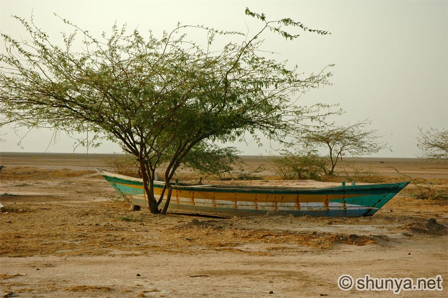
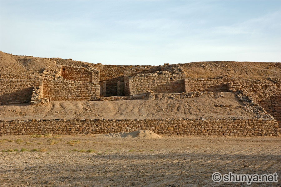
This comment has been removed by the author.
ReplyDeleteThis comment has been removed by the author.
ReplyDeleteWe are here perfect solution to any of your travel needs be it Flights booking, Bus bookings, Couple trips, Group travel or any customized tour to your wished place, we at Navbharat Tours plan it all for you.We just don’t simply believe in booking trips; we are in this industry since 60 years building ourselves and our expertise in creating once-in-a-lifetime experiences for our clients.
ReplyDeleteThanks for this blog visit on this link to get best tour travels in Corbett- Safari In Corbett
ReplyDeleteThanks for this useful information, this is really helping lot of people to want to visit and explore the places.
ReplyDeletewe are also from a best tour agency and tend to provide you best tour packages in crbett park if you are looking for a best wildlife tour so visit on- Jim Corbett National Park
ReplyDeleteRajasthan Tour Package
Jaipur Tour Package
Udaipur Tour Package
Jodhpur Tour Package
Jaipur Tour Package
Jaisalmer Tour Package
Mount-Abu Tour Package
Manali Tour Package
Shimla Manali Tour Package
Himachal Tour Package
Himachal with Amritsar Tour Package